


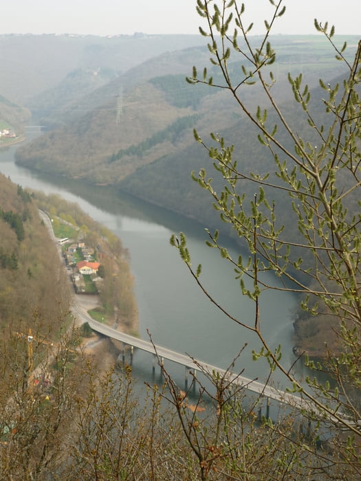
Die Tour startet in der luxemburgischen Stadt Vianden in der Nähe der Burg. Man steigt zunächst auf knapp 400 Meter Höhe und hat schöne Ausblicke über den Stausee und das deutsch - luxemburgische Grenzgebiet. Anschließend geht es talwerts, man quert den See über einen Steg und steigt auf der deutschen Seite wieder an. Anfangs folgt der Weg der Markierung gelber Punkt.
Tour gallery
Tour map and elevation profile
Minimum height 210 m
Maximum height 409 m
More about the tour author

|
JuliaHolg |
Comments

Die Stadt Vianden liegt direkt an der deutschen Grenze. Von Bitburg aus über die B50 zu erreichen. Parken kann man oberhalb der Burg auch kostenlos. Diese ist ausgeschildert und auch nicht zu übersehen.
GPS tracks
Trackpoints-
GPX / Garmin Map Source (gpx) download
-
TCX / Garmin Training Center® (tcx) download
-
CRS / Garmin Training Center® (crs) download
-
Google Earth (kml) download
-
G7ToWin (g7t) download
-
TTQV (trk) download
-
Overlay (ovl) download
-
Fugawi (txt) download
-
Kompass (DAV) Track (tk) download
-
Track data sheet (pdf) download
-
Original file of the author (gpx) download
More about the tour author
|
|
JuliaHolg |
Add to my favorites
Remove from my favorites
Edit tags
Open track
My score
Rate