Login

Forgot your login?

Cookies have to be accepted!
Your browser's cookie functionality is disabled. Please enable this functionality.

Not a member yet?

Register now
Login

Available for registred users only

Log in to use this feature.

Forgot your login?

Cookies have to be accepted!
Your browser's cookie functionality is disabled. Please enable this functionality.

Not a member yet?

Register now
Filter
Categories
Advanced filters
  • Distance (km)
  • Height
Save filters Reset filter

TrackRank

QRCode

Technical data

Distance84,0 km Height1912 m Way down1904 m Duration1 day 0 h Date18.08.2011
Scores Author Landscape Fun factor Fitness Technique

Statistics

2038 Views 1 Score 252 Downloads 4.00 Average
Rate
  • Track data sheet
  • Directions
  • Downloads
siehe: http://www.bergtour.ch/gipfelbuch/detail/id/50083

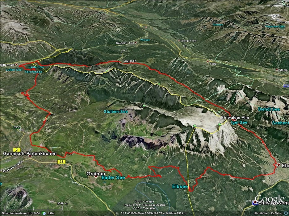
Tour map and elevation profile

  • Open Street Map
  • Google
Minimum height 734 m Maximum height 1610 m Detailed view

More about the tour author

jokermanex
Member since 2008

Send private message

Comments

gronzo on 19.09.2011

War Super

eine tolle tour mit allem was dazu! und auch nicht unbedingt dazu gehört. eben noch im erschlossenen hochalpinen gebiet, 5 min. später in garmisch,mittenwald .. umgeben von 100ten "anderen" touristen. toller tag, danke für's teilen
uweg on 20.07.2012

Genial

Start: Garmisch 14.00 uhr am Alpspitzbad nach 2o km und ca. 1000hm erste Übernachtung Hotel Diana Thörl http://www.zugspitzhotel.at/ super! Tag 2. Ehrwald- Ehrwalderalm- Seebenbsee- zweite Übernachtung Coburgerhütte wieder ca. 1000hm 20km Genial! Tag 3. 34km Down hill durch das schöne Gaißtal- Eis u Cappo in Mittenwald- auf schönem Trail zurück nach Garmisch!ca. 900hm ca. 30km. Ankunft:14.00 uhr Weil´s Wetter passt bin ich noch ohne gepäck auf das Kreuzeck gefahren mit tollem Down hill.
Wer das nichts selbst findet .....

GPS tracks

Trackpoints
  • GPX / Garmin Map Source (gpx) download
  • TCX / Garmin Training Center® (tcx) download
  • CRS / Garmin Training Center® (crs) download
  • Google Earth (kml) download
  • G7ToWin (g7t) download
  • TTQV (trk) download
  • Overlay (ovl) download
  • Fugawi (txt) download
  • Kompass (DAV) Track (tk) download
  • Track data sheet (pdf) download
  • Original file of the author (gpx) download

More about the tour author

jokermanex
Member since 2008

Send private message
Share track
Add to my favorites
Remove from my favorites
Edit tags
My score
Rate
Track: Zugspitz-Wetterstein-Umrundung
Type: Mountain bike
Distance: 84,0 km
Evaluated on:
Duration:
Day(s)
Hour(s)
Minute(s)
Score: Landscape Fun factor Fitness Technique