


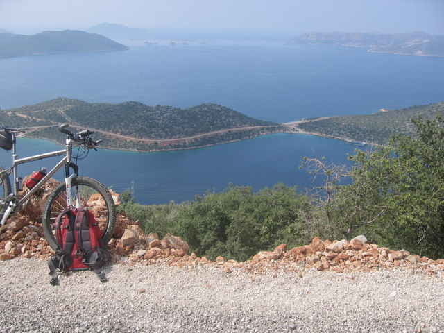
Traumhafte Aussicht auf Kas mit seiner Halbinsel und die Umgebung. Größtenteils Asphalt, letztes Stück steile Schotterstraße abwärts.
Für diese Region gibt auch es ein Buch von Werner Eichhorn (www.bike-guide-tuerkei.eu): Bike Guide Türkische Riviera, 2007 Bergverlag Rother, ISBN 978-3-7633-5017-9
Für diese Region gibt auch es ein Buch von Werner Eichhorn (www.bike-guide-tuerkei.eu): Bike Guide Türkische Riviera, 2007 Bergverlag Rother, ISBN 978-3-7633-5017-9
Tour gallery
Tour map and elevation profile
Minimum height -17 m
Maximum height 538 m
More about the tour author
|
|
berufsradler |
Comments
GPS tracks
Trackpoints-
GPX / Garmin Map Source (gpx) download
-
TCX / Garmin Training Center® (tcx) download
-
CRS / Garmin Training Center® (crs) download
-
Google Earth (kml) download
-
G7ToWin (g7t) download
-
TTQV (trk) download
-
Overlay (ovl) download
-
Fugawi (txt) download
-
Kompass (DAV) Track (tk) download
-
Track data sheet (pdf) download
-
Original file of the author (gpx) download
More about the tour author
|
|
berufsradler |
Add to my favorites
Remove from my favorites
Edit tags
Open track
My score
Rate
Schöne Tour
Schade ist eben der hohe Asphaltanteil.
Tour 20
(Die in ost/west Richtung verlaufende Rampe mit den zwei Serpentinen wurde leider unlängst asphaltiert)
CU
WE