


Landschaftlich sensationelle Tour von der Bezirksstadt Spittal aus direkt in den Nationalpark Nockberge.
Zunächst gehts gemütlich - quasi zum Aufwärmen - entland des Millstättersee-Radweges bis Döbriach. Von Radenthein gehts dann steil bergan ins Langalmtal, wo einige schöne Hütten stehen.
Ab der Erlacher Bockhütte wirds auch fahrtechnisch knifflig - ich konnte von dort an nicht mehr alles fahren und stieg teilweise ab. Die Passage ist aber nicht lange und umfasst ca. 500 Meter Luftlinie.
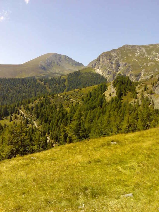
Von DER Bockhütte aus, gibts einen wunderbaren Blick auf den Rosennock (Foto), danach gehts rasend hinunter nach Bad Kleinkirchheim - und anschließend wieder bergauf. Vom Gegenhang bietet sich noch einmal ein schönes Panorama.
Zunächst gehts gemütlich - quasi zum Aufwärmen - entland des Millstättersee-Radweges bis Döbriach. Von Radenthein gehts dann steil bergan ins Langalmtal, wo einige schöne Hütten stehen.
Ab der Erlacher Bockhütte wirds auch fahrtechnisch knifflig - ich konnte von dort an nicht mehr alles fahren und stieg teilweise ab. Die Passage ist aber nicht lange und umfasst ca. 500 Meter Luftlinie.
Von DER Bockhütte aus, gibts einen wunderbaren Blick auf den Rosennock (Foto), danach gehts rasend hinunter nach Bad Kleinkirchheim - und anschließend wieder bergauf. Vom Gegenhang bietet sich noch einmal ein schönes Panorama.
Further information at
http://www.nationalparknockberge.at/Tour gallery
Tour map and elevation profile
Minimum height 545 m
Maximum height 1926 m
More about the tour author
|
|
texx |
Comments

Start am Fratresberg in Spittal.
GPS tracks
Trackpoints-
GPX / Garmin Map Source (gpx) download
-
TCX / Garmin Training Center® (tcx) download
-
CRS / Garmin Training Center® (crs) download
-
Google Earth (kml) download
-
G7ToWin (g7t) download
-
TTQV (trk) download
-
Overlay (ovl) download
-
Fugawi (txt) download
-
Kompass (DAV) Track (tk) download
-
Track data sheet (pdf) download
-
Original file of the author (gpx) download
More about the tour author
|
|
texx |
Add to my favorites
Remove from my favorites
Edit tags
Open track
My score
Rate