


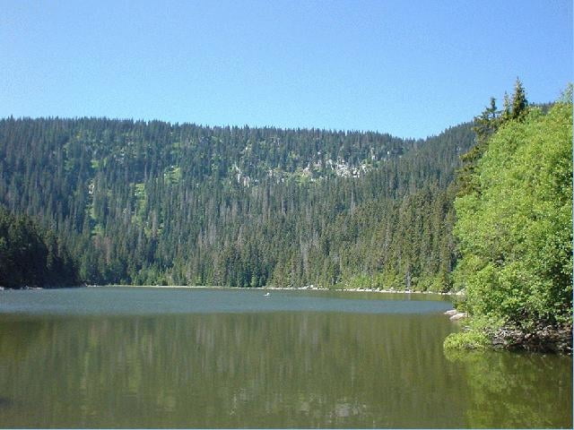
Tour zum "Auge des Böhmerwaldes" - Seine Entstehung geht bis in die Eiszeit zurück, als der Böhmerwald eines der größten Gebirge Mitteleuropas formte. Von Stifter oft beschrieben, ist der See noch immer von einem besonderen Zauber umgeben.
Ausgangspunkt dieser Tour ist in Schöneben bei Ulrichsberg.
Weg Nr. 801
Fordern Sie unsere Radkarte um EUR 3,00 hier an: info@boehmerwald.at!
Oder rufen Sie uns einfach an: Infotelefon +43 5 7890 100.
NEU - Elektrobikes im Verleih von Mai bis Oktober!
Further information at
http://www.boehmerwald.atgaléria trás
Mapa trasy a výškový profil
Minimum height 833 m
Maximum height 1090 m
More about the tour author
|
|
aigen-schlaegl |
komentáre

Mit dem Auto
ab Linz: B127 bis Rohrbach - Öpping - Aigen-Schlägl - Ulrichsberg - Schöneben
ab Passau: Grenzübergang Breitenberg - Klaffer - Ulrichsberg - Schöneben
ab Tschechien: Grenzübergang Zadni Zvonkova/Schöneben
Mit der Bahn: ab Linz-Mühlkreisbahnhof bis Bhf Aigen-Schlägl - weiter mit dem Bus http://www.oebb.at
Mit dem Bus: http://www.oebb.at
GPS trasy
Trackpoints-
GPX / Garmin Map Source (gpx) download
-
TCX / Garmin Training Center® (tcx) download
-
CRS / Garmin Training Center® (crs) download
-
Google Earth (kml) download
-
G7ToWin (g7t) download
-
TTQV (trk) download
-
Overlay (ovl) download
-
Fugawi (txt) download
-
Kompass (DAV) Track (tk) download
-
list trasy (pdf) download
-
Original file of the author (gpx) download
More about the tour author
|
|
aigen-schlaegl |
Add to my favorites
Remove from my favorites
Edit tags
Open track
My score
Rate