

This tour is full of landscape contrasts, monuments, forest and seaside as well.
To the people who dont know the area, drive caerfully, specially on the downhills, cause some of then can be a bit technichal. Enjoy as much as you can this tour, because i believe is one of the best ways to see all the area.p.s.s soon the photos will come:]
To the people who dont know the area, drive caerfully, specially on the downhills, cause some of then can be a bit technichal. Enjoy as much as you can this tour, because i believe is one of the best ways to see all the area.p.s.s soon the photos will come:]
Tour map and elevation profile
Minimum height 7 m
Maximum height 479 m
More about the tour author

|
icon8 |
Comments
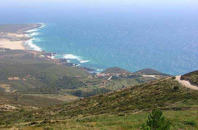
The tour starts in the historical center of Sintra near Quinta da Regaleira, then drive's you thrugh this points Seteais, Capuchos convent, Peninha convent, Azoia, Ulgueira, Praia da Adraga(beach), Praia Grande (beach), Colares, Mucifal, NAffarros, Galamares and back to sintra by Quinta da Regaleira.
GPS tracks
Trackpoints-
GPX / Garmin Map Source (gpx) download
-
TCX / Garmin Training Center® (tcx) download
-
CRS / Garmin Training Center® (crs) download
-
Google Earth (kml) download
-
G7ToWin (g7t) download
-
TTQV (trk) download
-
Overlay (ovl) download
-
Fugawi (txt) download
-
Kompass (DAV) Track (tk) download
-
Track data sheet (pdf) download
-
Original file of the author (g7t) download
More about the tour author
|
|
icon8 |
Add to my favorites
Remove from my favorites
Edit tags
Open track
My score
Rate
LUI
Nice landscape but ....
Really beautiful landscape and in parts nice ways but you have to walk alot ob this track!
And this is not becouse of minor skills or power. It is just impossible to drive up a way of deep sand...
If you think about doing the track - Do it but think about taking the road uphill to Sintra. The small pathes are not nice to walk up...
And down in the beach i would also recommend the road than the Sand dunes!