Login

Forgot your login?

Cookies have to be accepted!
Your browser's cookie functionality is disabled. Please enable this functionality.

Not a member yet?

Register now
Login

Available for registred users only

Log in to use this feature.

Forgot your login?

Cookies have to be accepted!
Your browser's cookie functionality is disabled. Please enable this functionality.

Not a member yet?

Register now
Filter
Categories
Advanced filters
  • Distance (km)
  • Height
Save filters Reset filter

TrackRank

QRCode

Technical data

Distance30,7 km Height253 m Way down184 m Duration02:00 h:m Date16.09.2012
Scores Author Landscape Fun factor Fitness Technique

Statistics

609 Views 1 Score 37 Downloads 2.00 Average
Rate
  • Track data sheet
  • Directions
  • Downloads

15.09.2012

Von Angermund aus zum Blauen See. Achtung: kurzes Stück mit Kurve und  starkem Gefälle am Blauen See.

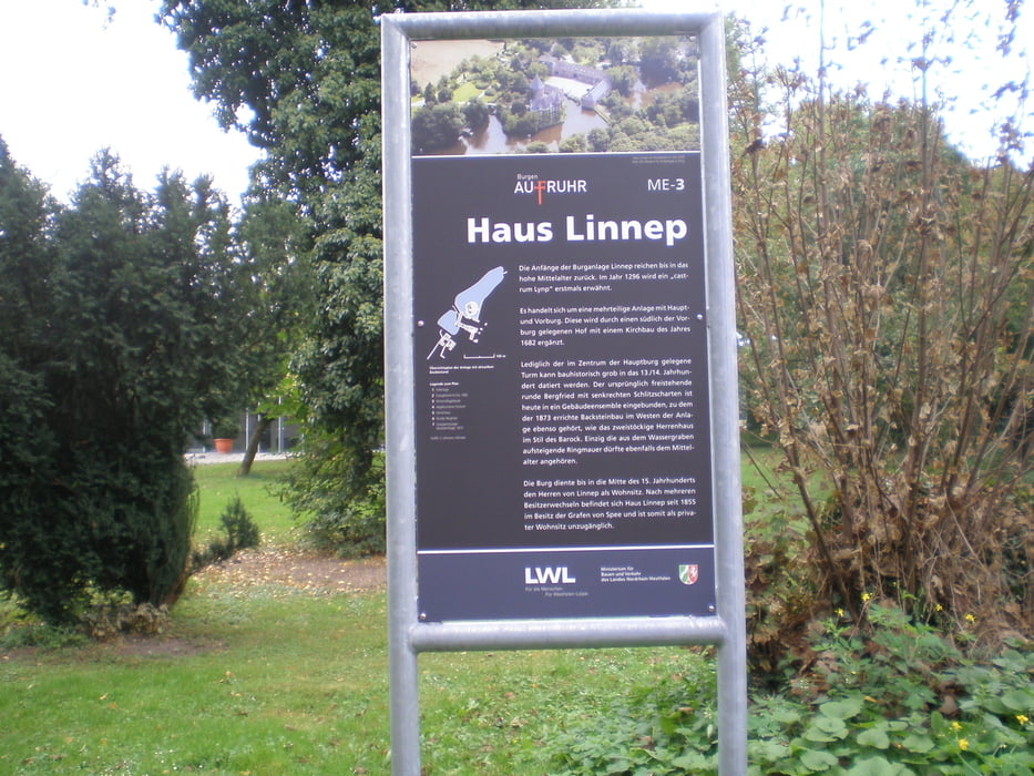
Dann durch die Wälder von Ratingen, an Schloss Linnep vorbei zurück nach Angermund.

Strecke ist überwiegend Schotter, deshalb Mountainbike zu empfehlen.

Tour gallery

Tour map and elevation profile

  • Open Street Map
  • Google
Minimum height -34 m Maximum height 94 m Detailed view

More about the tour author

GuenterM
Member since 2010

Send private message

Comments

GPS tracks

Trackpoints
  • GPX / Garmin Map Source (gpx) download
  • TCX / Garmin Training Center® (tcx) download
  • CRS / Garmin Training Center® (crs) download
  • Google Earth (kml) download
  • G7ToWin (g7t) download
  • TTQV (trk) download
  • Overlay (ovl) download
  • Fugawi (txt) download
  • Kompass (DAV) Track (tk) download
  • Track data sheet (pdf) download
  • Original file of the author (gpx) download

More about the tour author

GuenterM
Member since 2010

Send private message
Share track
Add to my favorites
Remove from my favorites
Edit tags
My score
Rate
Track: Blauer See - Burg Linnep
Type: Mountain bike
Distance: 30,7 km
Evaluated on:
Duration:
Day(s)
Hour(s)
Minute(s)
Score: Landscape Fun factor Fitness Technique