

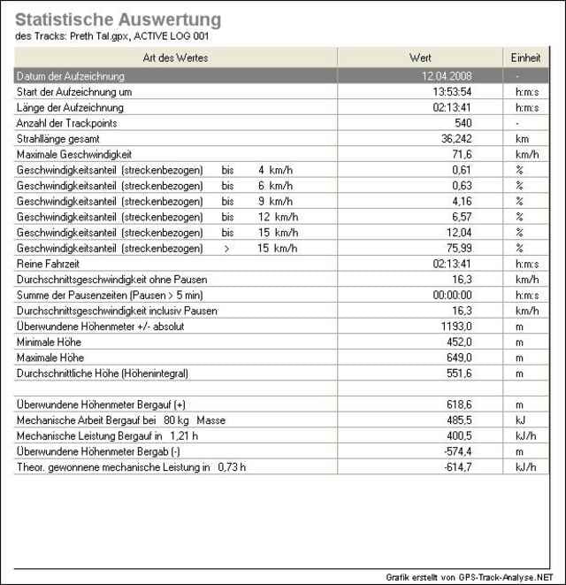
Min.Höhe : 452 m
Max.Höhe : 649 m
Aufstiegsmeter : 619 m
Asphalt : 8 km
Waldwege : 25 km
Wirtschaftwege : 5 km
Wir starten direkt vor der Haustür der Ferienhäuser in Kronenburg und verlassen und machen auf der Fahrt nach Baasem direkt mal ca. 100 hm zunichte.
Von Baasem aus fahren wir bis zur L110 immer der Simmel nach. Nach der Straßenquerung ist fahren wir bis zum "Mooskreuz" hinab, wo uns ein ca. 1 km Trail erwartet.
Vorbei an Wolfert und Sieberath fahren durch ein Tal ca. 150 hm auf die Anhöhe bei Rescheid (ca. 610 müNN). Nachdem wir die K68 gequert haben fahren wir hinab zum Prether Bach.
Diesem Bach folgen wir dann ca. 7 km bis wir über die L110 zurück nach Kronenburg fahren.
Further information at
http://www.ferienhaeuser-brandenburg.comTour gallery
Tour map and elevation profile
Minimum height 452 m
Maximum height 649 m
More about the tour author
|
|
eifeler |
Comments

Die Anfahrt können Sie sich hier berechnen lassen:
web2.cylex.de/anfahrt/ferienhaeuser-brandenburg-4985276.htmlGPS tracks
Trackpoints-
GPX / Garmin Map Source (gpx) download
-
TCX / Garmin Training Center® (tcx) download
-
CRS / Garmin Training Center® (crs) download
-
Google Earth (kml) download
-
G7ToWin (g7t) download
-
TTQV (trk) download
-
Overlay (ovl) download
-
Fugawi (txt) download
-
Kompass (DAV) Track (tk) download
-
Track data sheet (pdf) download
-
Original file of the author (gpx) download
More about the tour author
|
|
eifeler |
Add to my favorites
Remove from my favorites
Edit tags
Open track
My score
Rate