Login

Forgot your login?

Cookies have to be accepted!
Your browser's cookie functionality is disabled. Please enable this functionality.

Not a member yet?

Register now
Login

Available for registred users only

Log in to use this feature.

Forgot your login?

Cookies have to be accepted!
Your browser's cookie functionality is disabled. Please enable this functionality.

Not a member yet?

Register now
Filter
Categories
Advanced filters
  • Distance (km)
  • Height
Save filters Reset filter

TrackRank

QRCode

Technical data

Distance21,1 km Height514 m Way down529 m Duration07:00 h:m Date25.03.2017
Scores Author Landscape Fun factor Fitness Technique

Statistics

569 Views Scores 12 Downloads Average
Rate
  • Track data sheet
  • Directions
  • Downloads

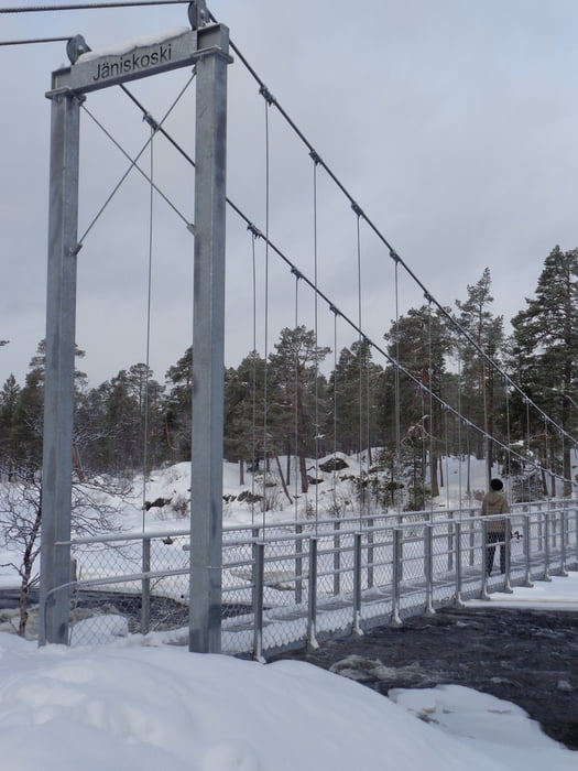
Von Inari auf Juutua-Trail in 3/4 Std. zur Jäniskoski-Brücke. An der Feuerstelle rechts vorbei und den roten Pfählen folgen nach Laurin Iaavu (3/4 Std.). Weiter auf dem markierten Weg; eine Steilstufe kann rechts oder links umgangen werden, dann wieder etwas flacher hinauf auf den Gipfel (2 Std.). Der Rückweg erfolgt bis zur Jäniskoski-Brücke auf dem Anstiegsweg. Hier weiter auf dem Jutuua-Trail zum Siida-Museum und über den See nach Inari (3 1/4 Std.).


Tour gallery

Tour map and elevation profile

  • Open Street Map
  • Google
Minimum height 84 m Maximum height 424 m Detailed view

More about the tour author

JoHangler
Member since 2013

Send private message

Comments

Vom Flughafen Ivalo auf der Bundesstraße 4 (E75) nach Inari.


GPS tracks

Trackpoints
  • GPX / Garmin Map Source (gpx) download
  • TCX / Garmin Training Center® (tcx) download
  • CRS / Garmin Training Center® (crs) download
  • Google Earth (kml) download
  • G7ToWin (g7t) download
  • TTQV (trk) download
  • Overlay (ovl) download
  • Fugawi (txt) download
  • Kompass (DAV) Track (tk) download
  • Track data sheet (pdf) download
  • Original file of the author (gpx) download

More about the tour author

JoHangler
Member since 2013

Send private message
Share track
Add to my favorites
Remove from my favorites
Edit tags
My score
Rate
Track: Von Inari auf den Otsumo
Type: Snowshoeing
Distance: 21,1 km
Evaluated on:
Duration:
Day(s)
Hour(s)
Minute(s)
Score: Landscape Fun factor Fitness Technique