Login

Forgot your login?

Cookies have to be accepted!
Your browser's cookie functionality is disabled. Please enable this functionality.

Not a member yet?

Register now
Login

Available for registred users only

Log in to use this feature.

Forgot your login?

Cookies have to be accepted!
Your browser's cookie functionality is disabled. Please enable this functionality.

Not a member yet?

Register now
Filter
Categories
Advanced filters
  • Distance (km)
  • Height
Save filters Reset filter

TrackRank

QRCode

Technical data

Distance6,7 km Height527 m Way down525 m Duration03:15 h:m Date07.05.2017
Scores Author Landscape Fun factor Fitness Technique

Statistics

315 Views Scores 24 Downloads Average
Rate
  • Track data sheet
  • Directions
  • Downloads

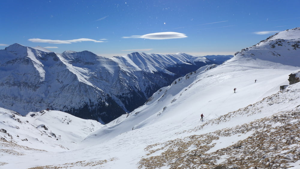
Von der Cabana Balea Lac über den zugefrorenen See. Am Ende des Sees steil nach Süden zum Fereastra Bâlei aufsteigen. Die Scharte ein paar Meter hinunter und dann nach rechts durch das flache Hochtal ansteigen. Zuletzt etwas steiler in den Sattel und von dort über die SO-Flanke zum Gipfel des Paltinu.

Abfahrt vom Gipfel entlang des Aufstiegs, am Ende des Hochtals steil  hinunter nach Süden zu einem kurzen Flachstück.  Durch die anschließende Rinne wäre eine steile Abfahrt bis zum Tunnelportal und darüber hinaus möglich.

Wir steigen jedoch schon hier wieder auf in nordwestlicher Richtung zum Izeru Caprei den wir über seine Südflanke erklimmen.

Die Abfahrt erfolgt nach Westen entlang des Grates um ohne Gegenanstieg das Fereastrea Bâlei zu erreichen. Von hier Abfahrt nach Norden zur Cabana Balea Lac

 Jahreszeit der Tour: Mitte Februar

Tour gallery

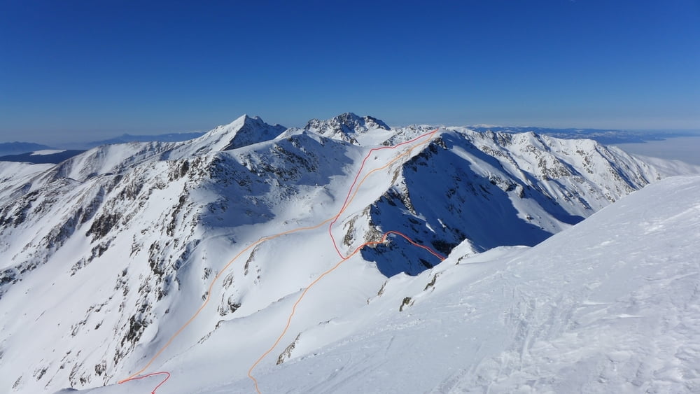
Tour map and elevation profile

  • Open Street Map
  • Google
Minimum height 2024 m Maximum height 2382 m Detailed view

More about the tour author

Gi
Member since 2010

Send private message

Comments

Von Sibiu auf der DN1 und dann der 7c bis nach Bale Cascada. Von hier mit Ski oder der Seilbahn zum Balea Lac.

GPS tracks

Trackpoints
  • GPX / Garmin Map Source (gpx) download
  • TCX / Garmin Training Center® (tcx) download
  • CRS / Garmin Training Center® (crs) download
  • Google Earth (kml) download
  • G7ToWin (g7t) download
  • TTQV (trk) download
  • Overlay (ovl) download
  • Fugawi (txt) download
  • Kompass (DAV) Track (tk) download
  • Track data sheet (pdf) download
  • Original file of the author (gpx) download

More about the tour author

Gi
Member since 2010

Send private message
Share track
Add to my favorites
Remove from my favorites
Edit tags
My score
Rate
Track: Vf. Paltinu und Vf. Iezeru Caprei
Type: Ski touring
Distance: 6,7 km
Evaluated on:
Duration:
Day(s)
Hour(s)
Minute(s)
Score: Landscape Fun factor Fitness Technique