Login

Forgotten password?

Cookies have to be accepted!
Your browser's cookie functionality is disabled. Please enable this functionality.

Not a member yet?

Register now
Login

Available for registred users only

Log in to use this feature.

Forgotten password?

Cookies have to be accepted!
Your browser's cookie functionality is disabled. Please enable this functionality.

Not a member yet?

Register now
Filter
Categories
Advanced filters
  • Distance (km)
  • Height
Save filters Reset filter

TrackRank

QRCode

Technical data

Distance79,3 km Height919 m Way down976 m Duration03:00 h:m Date28.06.2006
Scores Author Landscape Fun factor Fitness Technique

Statistics

784 Views Scores 158 Downloads Average
Rate
  • Track data sheet
  • Directions
  • Downloads
Sehr schöne Runde zunächst Richtung Falkenstein, dann in in einem kleinen Dorf (Stadl) Richtung Norden auf kleinen Straßen nach Nittenau und über Kürn mit weiteren teils heftigen kurzen Anstiegen zurück nach Regensburg.

Tour gallery

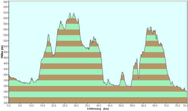
Tour map and elevation profile

  • Open Street Map
  • Google
Minimum height 340 m Maximum height 617 m Detailed view

More about the tour author

tobi_74

Comments

Der Startpunkt befindet sich im Nordosten von Regensburg, dem Gewerbepark.

GPS tracks

Trackpoints
  • GPX / Garmin Map Source (gpx) download
  • TCX / Garmin Training Center® (tcx) download
  • CRS / Garmin Training Center® (crs) download
  • Google Earth (kml) download
  • G7ToWin (g7t) download
  • TTQV (trk) download
  • Overlay (ovl) download
  • Fugawi (txt) download
  • Kompass (DAV) Track (tk) download
  • Track data sheet (pdf) download
  • Original file of the author (gpx) download

More about the tour author

tobi_74

Share track
Add to my favorites
Remove from my favorites
Edit tags
My score
Rate
Track: Regensburg - Stadl, Nittenau
Type: Road biking
Distance: 79,3 km
Evaluated on:
Duration:
Day(s)
Hour(s)
Minute(s)
Score: Landscape Fun factor Fitness Technique