Login

Forgotten password?

Cookies have to be accepted!
Your browser's cookie functionality is disabled. Please enable this functionality.

Not a member yet?

Register now
Login

Available for registred users only

Log in to use this feature.

Forgotten password?

Cookies have to be accepted!
Your browser's cookie functionality is disabled. Please enable this functionality.

Not a member yet?

Register now
Filter
Categories
Advanced filters
  • Distance (km)
  • Height
Save filters Reset filter

TrackRank

QRCode

Technical data

Distance71,9 km Height564 m Way down562 m Duration02:23 h:m Date05.07.2006
Scores Author Landscape Fun factor Fitness Technique

Statistics

1581 Views Scores 205 Downloads Average
Rate
  • Track data sheet
  • Directions
  • Downloads
Marienthalrunde zunächst Richtung Falkenstein, bei Altenthann abgezweigt nach Nittenau und im Regenthal zurück nach Regensburg. Im Regenthal wird eine Variante über Ramspau gefahren.
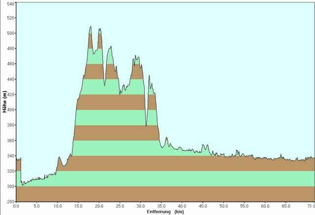
Dauer 02:23:00 bei 30 km/h Schnitt, 592 Höhenmeter.

Tour gallery

Tour map and elevation profile

  • Open Street Map
  • Google
Minimum height 301 m Maximum height 509 m Detailed view

More about the tour author

tobi_74

Comments

Der Startpunkt befindet sich im Nordosten von Regensburg, im Gewerbepark.

GPS tracks

Trackpoints
  • GPX / Garmin Map Source (gpx) download
  • TCX / Garmin Training Center® (tcx) download
  • CRS / Garmin Training Center® (crs) download
  • Google Earth (kml) download
  • G7ToWin (g7t) download
  • TTQV (trk) download
  • Overlay (ovl) download
  • Fugawi (txt) download
  • Kompass (DAV) Track (tk) download
  • Track data sheet (pdf) download
  • Original file of the author (gpx) download

More about the tour author

tobi_74

Share track
Add to my favorites
Remove from my favorites
Edit tags
My score
Rate
Track: Regensburg - Altenthann, Nittenau, Marienthal
Type: Road biking
Distance: 71,9 km
Evaluated on:
Duration:
Day(s)
Hour(s)
Minute(s)
Score: Landscape Fun factor Fitness Technique