Login

Forgot your login?

Cookies have to be accepted!
Your browser's cookie functionality is disabled. Please enable this functionality.

Not a member yet?

Register now
Login

Available for registred users only

Log in to use this feature.

Forgot your login?

Cookies have to be accepted!
Your browser's cookie functionality is disabled. Please enable this functionality.

Not a member yet?

Register now
Filter
Categories
Advanced filters
  • Distance (km)
  • Height
Save filters Reset filter

TrackRank

QRCode

Technical data

Distance42,0 km Height726 m Way down675 m Duration03:00 h:m Date21.08.2011
Scores Author User Landscape Fun factor Fitness Technique

Statistics

2268 Views 2 Scores 152 Downloads 3.00 Average
Rate
  • Track data sheet
  • Directions
  • Downloads

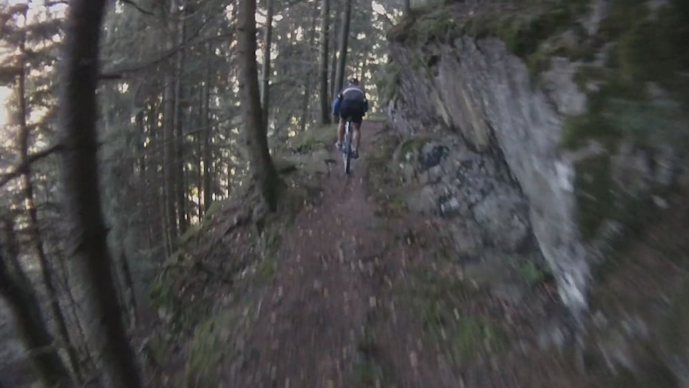
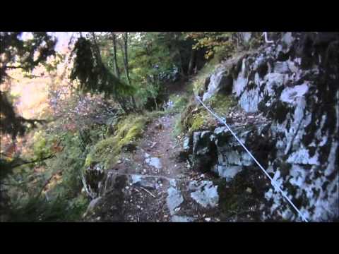
Very impressive tour with very difficult parts. Cycling on the edge of a canyon. Please be very careful. Walk the bike at the rim and use the hand rails. Don't try to ride it like in the video.

A lot of roots and stones. Drive only if it's dry.

Tour gallery

Tour map and elevation profile

  • Open Street Map
  • Google
Minimum height 342 m Maximum height 991 m Detailed view

More about the tour author

kiri
Member since 2011

Send private message

Comments

Odin on 08.06.2012

gefahren 28.05.2012

Ich bin hin- und her gerissen mit der Bewertung dieser Tour.
Die ersten Kilometer rollt man auf Asphalt, später auf Waldwegen, stets aufwärts, zum Ende etwas steiler, aber immer gut fahrbar. Oben angekommen, beginnt der Trail, teilweise ziemlich verblockt und eng, richtig flowig wird es nie. Von der Gesamtstrecke sind nur ca. 6Km Trail. Dieser Streckenabschnitt jedoch fordert volle Konzentration und in bestimmten Abschnitten auch perfekte Fahrradbeherrschung. Wer technisch nicht fit ist, dem kann diese Tour nicht empfohlen werden.
Der Heimweg erfolgt dann wieder auf dem gleichen Weg mit Schotter und Asphalt.
Fazit: ich hätte mir weniger Asphalt und Waldautobahn gewünscht, dafür später etwas flowigere Trails. Ein Nervenkitzel bleibt es ohne Frage.
Soaring138 on 09.06.2015

Schönes Video !

ich habe mir zwar im Moment nur das Video angeschaut. Und ich muss sagen, dass die asphaltierte Straße sich höchstwahrscheinlich lohnt !
See you later !
BRUNO

From Tiengen drive up to Attlisberg, Höchenschwand and then follow the GPS track.

Your tour will end in Tiengen again.

GPS tracks

Trackpoints
  • GPX / Garmin Map Source (gpx) download
  • TCX / Garmin Training Center® (tcx) download
  • CRS / Garmin Training Center® (crs) download
  • Google Earth (kml) download
  • G7ToWin (g7t) download
  • TTQV (trk) download
  • Overlay (ovl) download
  • Fugawi (txt) download
  • Kompass (DAV) Track (tk) download
  • Track data sheet (pdf) download
  • Original file of the author (gpx) download

More about the tour author

kiri
Member since 2011

Send private message
Share track
Add to my favorites
Remove from my favorites
Edit tags
My score
Rate
Track: Tiengen - Höchenschwand - Felsenweg (Video) (Dangerous!)
Type: Mountain bike
Distance: 42,0 km
Evaluated on:
Duration:
Day(s)
Hour(s)
Minute(s)
Score: Landscape Fun factor Fitness Technique