

English below:
Dieses ist eine einfache Wanderung nahe dem berühmten "onsen" Stadt von Hakone. Von der Bushaltestelle gehen Sie herauf die Spur zur Kante, gerade unter Kintoko-San (Berg). Drehen Sie sich nach rechts und folgen Sie der Kante, die zu erstem Myujin-dake Südost sind (ein guter Platz für das Mittagessen) und dann Myouho-dake. Von steigen in das Dorf von Miyagino ab und nehmen den Bus zurück zu Hakone-yumoto. Es gibt große Ansichten der Einfassung Fuji, des pazifischen Ozeans und der Hakone Senke.
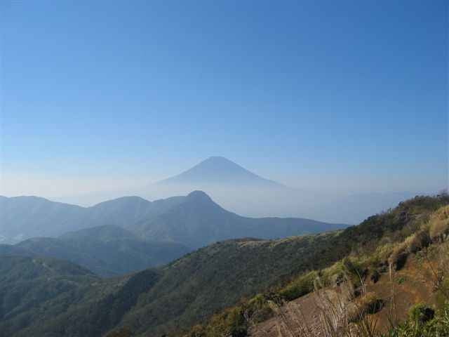
This is an easy hike near the famous "onsen" town of Hakone. From the bus stop, walk up the trail to the ridge, just below Kintoko-san (mountain). Turn right, and follow the ridge south-east to first Myujin-dake (a good place for lunch), and then Myouho-dake. From there descend into the village of Miyagino, and take the bus back to Hakone-yumoto. There are great views of Mount Fuji, the Pacific Ocean, and the Hakone valley.
Dieses ist eine einfache Wanderung nahe dem berühmten "onsen" Stadt von Hakone. Von der Bushaltestelle gehen Sie herauf die Spur zur Kante, gerade unter Kintoko-San (Berg). Drehen Sie sich nach rechts und folgen Sie der Kante, die zu erstem Myujin-dake Südost sind (ein guter Platz für das Mittagessen) und dann Myouho-dake. Von steigen in das Dorf von Miyagino ab und nehmen den Bus zurück zu Hakone-yumoto. Es gibt große Ansichten der Einfassung Fuji, des pazifischen Ozeans und der Hakone Senke.
This is an easy hike near the famous "onsen" town of Hakone. From the bus stop, walk up the trail to the ridge, just below Kintoko-san (mountain). Turn right, and follow the ridge south-east to first Myujin-dake (a good place for lunch), and then Myouho-dake. From there descend into the village of Miyagino, and take the bus back to Hakone-yumoto. There are great views of Mount Fuji, the Pacific Ocean, and the Hakone valley.
Más información en
http://malcomson.com/gallery/hakone2004Galería de rutas

Mapa de la ruta y perfil de altitud
Minimum height 172 m
Maximum height 1181 m
More about the tour author

|
zangezur |
Comentarios

More about the tour author
|
|
zangezur |
Añadir a mis favoritos
Eliminar de mis favoritos
Edit tags
Open track
Mi valoración
Rate