Login

Login oublié ?

Cookies have to be accepted!
Your browser's cookie functionality is disabled. Please enable this functionality.

Not a member yet?

Register now
Login

Available for registred users only

Log in to use this feature.

Login oublié ?

Cookies have to be accepted!
Your browser's cookie functionality is disabled. Please enable this functionality.

Not a member yet?

Register now
Filter
Catégories
Advanced filters
  • Longueur (km)
  • Altimètre
Enregistrer le filtre Reset filter

TrackRank

QRCode

Technical data

Longueur10,0 km Altimètre1001 m Way down915 m Durée03:45 h:m Date16.10.2004
Evaluations Author Paysage Aspect amusement Condition Technique

Statistiques

6006 Vues 2 Evaluations 565 Téléchargements 4.00 Moyenne
Rate
  • Feuille de tours
  • Arrivée
  • Téléchargements
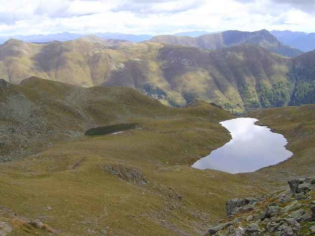
Start ist bereits oberhalb der Waldgrenze - auf der Emberger Alm - oberhalb von Greifenburg. Via den Naßfeldriegel wandert man hinauf bis zum Gipfel - tolle Aussicht. Der Rückweg erfolgt über die Nordseite - vorbei an den glasklaren Zweiseen bis zurück zur Alm.

Further information at

http://www.forellemueller.at

Galerie du tour

Carte du tour et altitude

  • Open Street Map
  • Google
Minimum height 1678 m Maximum height 2538 m Vue de détail

More about the tour author

forelle
Member since 2004

Send private message

Commentaires

Bruni Braun on 17.09.2006

Am Anfang über die Skipiste langweilig. Dann sehr schön und interssant.
Helmut Vacek on 03.09.2007

Tour 928 Hochtristen

Eine wunderschöne Tour, nur die 3h 45 min scheinen sehr tief gegriffen. wir hatten ca. 5h reine Gehzeit, obwohl wir ziemlich flott unterwegs waren.
Spittal - Greifenburg - vorm Billa links hinauf bis zur Emberger Alm (Asphaltstraße).

Tracks GPS

Trackpoints
  • GPX / Garmin Map Source (gpx) download
  • TCX / Garmin Training Center® (tcx) download
  • CRS / Garmin Training Center® (crs) download
  • Google Earth (kml) download
  • G7ToWin (g7t) download
  • TTQV (trk) download
  • Overlay (ovl) download
  • Fugawi (txt) download
  • Kompass (DAV) Track (tk) download
  • Feuille de tours (pdf) download
  • Original file of the author (g7t) download

More about the tour author

forelle
Member since 2004

Send private message
Share track
Add to my favorites
Remove from my favorites
Edit tags
My score
Rate
Tour: Hochtristen - Kreuzeckgruppe
Cat.: Tour en montagne
Longueur: 10,0 km
Evaluated on:
Durée:
Day(s)
Hour(s)
Minute(s)
Evaluation: Paysage Aspect amusement Condition Technique