Login

Login vergessen?

Cookies müssen akzeptiert werden!
Die Cookie-Funktion Ihres Browsers ist deaktiviert. Bitte aktivieren Sie die Funktion.

Noch kein Mitglied?

Jetzt Registrieren
Login

Nur für eingeloggte Benutzer möglich

Melde dich an, um diese Funktion nutzen zu können.

Login vergessen?

Cookies müssen akzeptiert werden!
Die Cookie-Funktion Ihres Browsers ist deaktiviert. Bitte aktivieren Sie die Funktion.

Noch kein Mitglied?

Jetzt Registrieren
Filter
Kategorien
Erweiterte Filter
  • Länge (km)
  • Höhenmeter
Filter speichern Filter zurücksetzen

TrackRank

QRCode

Technische Daten

Länge163,4 km Höhenmeter1570 m Abstieg730 m Dauer07:30 h:m Datum07.01.2009
Bewertungen Autor Landschaft Spaßfaktor Kondition Technik

Statistik

237 Views Bewertungen 18 Downloads Durchschnitt
Bewerten
  • Tourenblatt
  • Anfahrt
  • Downloads

The long all roads track of the island. There is not much left that contains tarmack and is not included in this track.

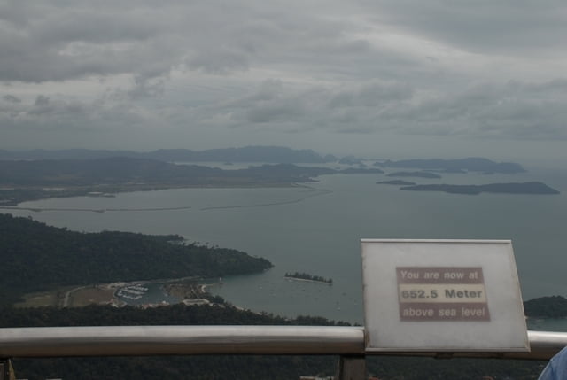
Pretty up and down course with an 13km up to 10% steep climb onto the island's highest mountain Gunung Raya. Up there is Celkom/Telkom station and a resort(?) where you could possibly stay overnight. Additionally there is a tourist look out point/tower for RM 10,/ you can get even approximately 10m higher and have a nice view of the complete island. On a good day, you can see to Thailand's mainland and all the remaining 103 Langkawi archipel islands.

The north west track takes you to the exclusive and very nice Datai Golf club, the north route goes to Tanjung Rhu beach, whereas in the south east you can explore Porto Malai and the tourist beaches of Tangah and Cenang.

No need to take much of supplies with, as almost everywhere you can stop and buy some food and drinks...

...well, even most of the Langkawi visitors would most likely go on this tour by car, as the conditions are quite challenging for cycling. Hot, humid and occassionally quite windy it gives you a good feeling about how the Ironman athletes feel when competing here in February.

Tour Galerie

Tour Karte und Höhenprofil

  • Open Street Map
  • Google
Minimale Höhe -10 m Maximale Höhe 853 m Detailansicht

Mehr zum Tourautor

mblanarik
Mitglied seit 2006

Land: Deutschland

47 erstellte Touren
6.7
Private Nachricht senden

Kommentare

...once you got to Malaysia, you can either fly to Langkawi or take a ferry from Penang, Kuala Kedah or Kuala Perlis.

Alternatively you can fly in from Singapore or Thailand.

GPS-Tracks

Trackpunkte
  • GPX / Garmin Map Source (gpx) download
  • TCX / Garmin Training Center® (tcx) download
  • CRS / Garmin Training Center® (crs) download
  • Google Earth (kml) download
  • G7ToWin (g7t) download
  • TTQV (trk) download
  • Overlay (ovl) download
  • Fugawi (txt) download
  • Kompass (DAV) Track (tk) download
  • Tourenblatt (pdf) download
  • Originaldatei des Autors (gpx) download

Mehr zum Tourautor

mblanarik
Mitglied seit 2006

Land: Deutschland

47 erstellte Touren
6.7
Private Nachricht senden
Tour teilen
Zu meinen Favoriten hinzufügen
Von meinen Favoriten entfernen
Tags bearbeiten
Meine Bewertung
Bewerten
Tour: Langkawi - the all road tour
Art: Rennrad
Länge: 163,4 km
Bewertet am:
Dauer:
Tag(e)
Stunde(n)
Minute(n)
Bewertung: Landschaft Spaßfaktor Kondition Technik