Login

Forgot your login?

Cookies have to be accepted!
Your browser's cookie functionality is disabled. Please enable this functionality.

Not a member yet?

Register now
Login

Available for registred users only

Log in to use this feature.

Forgot your login?

Cookies have to be accepted!
Your browser's cookie functionality is disabled. Please enable this functionality.

Not a member yet?

Register now
Filter
Categories
Advanced filters
  • Distance (km)
  • Height
Save filters Reset filter

TrackRank

QRCode

Technical data

Distance1,9 km Height463 m Way down1 m Duration00:00 h:m Date18.08.2012
Scores Author User Landscape Fun factor Fitness Technique

Statistics

1031 Views 1 Score 36 Downloads 5.00 Average
Rate
  • Track data sheet
  • Directions
  • Downloads

From Karlsbader Hütte (2260 m a.s.l.) to Seekofel (2744 m a.s.l.) via Seekofel Klettersteig - http://www.bergsteigen.at/de/touren.aspx?ID=1891 .

See the photos at http://zbartos.rajce.idnes.cz/VHT_Lienzer_Dolomiten_27.-28.7._2012_-_4._a_5._den/

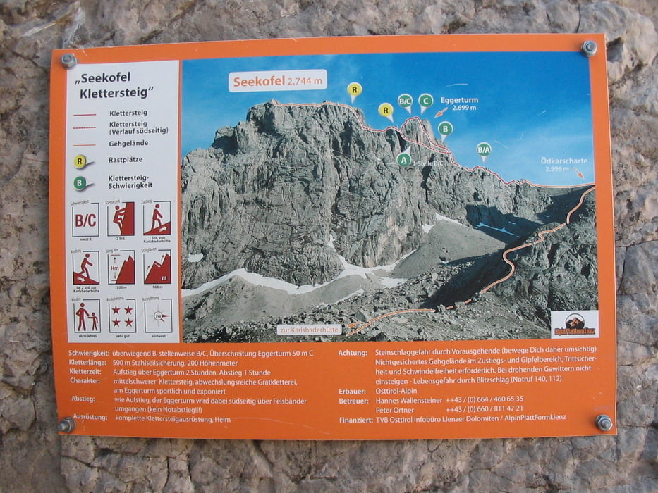
Tour map and elevation profile

  • Open Street Map
  • Google
Minimum height 2260 m Maximum height 2746 m Detailed view

More about the tour author

zbartos
Member since 2006

Send private message

Comments

GPS tracks

Trackpoints
  • GPX / Garmin Map Source (gpx) download
  • TCX / Garmin Training Center® (tcx) download
  • CRS / Garmin Training Center® (crs) download
  • Google Earth (kml) download
  • G7ToWin (g7t) download
  • TTQV (trk) download
  • Overlay (ovl) download
  • Fugawi (txt) download
  • Kompass (DAV) Track (tk) download
  • Track data sheet (pdf) download
  • Original file of the author (gpx) download

More about the tour author

zbartos
Member since 2006

Send private message
Share track
Add to my favorites
Remove from my favorites
Edit tags
My score
Rate
Track: Lienzer Dolomiten - Seekofel Klettersteig
Type: Via ferrata
Distance: 1,9 km
Evaluated on:
Duration:
Day(s)
Hour(s)
Minute(s)
Score: Landscape Fun factor Fitness Technique