Login

Forgotten password?

Cookies have to be accepted!
Your browser's cookie functionality is disabled. Please enable this functionality.

Not a member yet?

Register now
Login

Available for registred users only

Log in to use this feature.

Forgotten password?

Cookies have to be accepted!
Your browser's cookie functionality is disabled. Please enable this functionality.

Not a member yet?

Register now
Filter
Categories
Advanced filters
  • Distance (km)
  • Height
Save filters Reset filter

TrackRank

QRCode

Technical data

Distance33,5 km Height1851 m Way down1871 m Duration04:00 h:m Date19.11.2012
Scores Author Landscape Fun factor Fitness Technique

Statistics

1151 Views Scores 64 Downloads Average
Rate
  • Track data sheet
  • Directions
  • Downloads

Eine große Schleife am Walchensee mit "Anlauf" von Kochel über den Kesselberg.

Kaffee und Kuchen gab es diesmal in Urfeld im Cafe Seestüberl (Mi/Do Ruhetag).

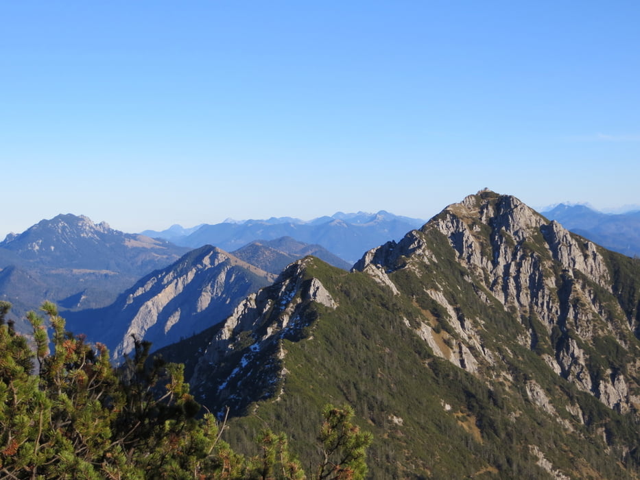
Hohepunkte der Tour waren der Gratweg zum Heimgarten mit spekakulären Ausblicken und der "technische" Trail vom Heimgarten nach Walchensee.


Tour gallery

Tour map and elevation profile

  • Open Street Map
  • Google
Minimum height 588 m Maximum height 1787 m Detailed view

More about the tour author

Mathis_muc
Member since 2008

Send private message

Comments

Anfahrt über A96 Ausfahrt Großweil/Kochel

Kurz nach Ortsbeginn Kochen rechts auf Parkplatz abbiegen, umziehen und loslaufen...

GPS tracks

Trackpoints
  • GPX / Garmin Map Source (gpx) download
  • TCX / Garmin Training Center® (tcx) download
  • CRS / Garmin Training Center® (crs) download
  • Google Earth (kml) download
  • G7ToWin (g7t) download
  • TTQV (trk) download
  • Overlay (ovl) download
  • Fugawi (txt) download
  • Kompass (DAV) Track (tk) download
  • Track data sheet (pdf) download
  • Original file of the author (gpx) download

More about the tour author

Mathis_muc
Member since 2008

Send private message
Share track
Add to my favorites
Remove from my favorites
Edit tags
My score
Rate
Track: Kochel-Herzogstand-Heimgarten-Trail
Type: Mountain hiking
Distance: 33,5 km
Evaluated on:
Duration:
Day(s)
Hour(s)
Minute(s)
Score: Landscape Fun factor Fitness Technique