

Start in Reinbek-Hinschendorf, durchs Bergedorfer Gehölz nach Wentorf, über Sternwarte und Geestkante zur Dalbekschlucht, Escheburg Sportplatz, Bistal, (Geesthacht) Heidbergring, obere Geestkante zurück bis Dalbekschlucht, Kröppelshagen, Friedrichsruher Weg nach Friedrichsruh/Aumühle zum Wanderweg Nr. 6, Billetrail (X) zurück bis Wohltorf, über Reinbek Mühlenteich nach Reinbek-Hinschendorf
Konditionell anspruchsvoll, aber so ziemlich alle landschaftlichen Highlights der Gegend dabei.
Erweiterbar durch Billetrail im Sachsenwald ( Richtung Witzhave ), oder östlich Richtung Lauenburg
Further information at
http://www.mtb-news.deTour gallery
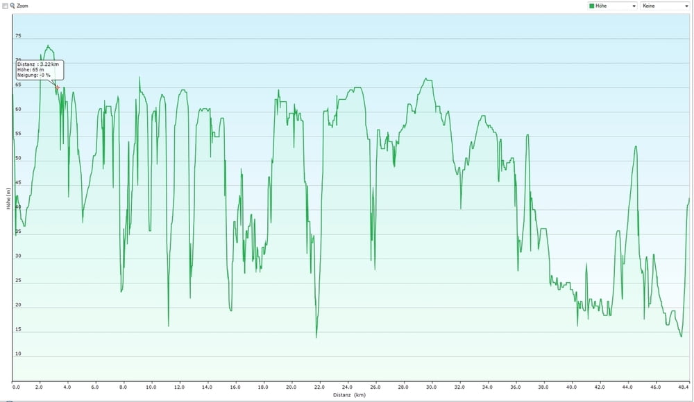
Tour map and elevation profile
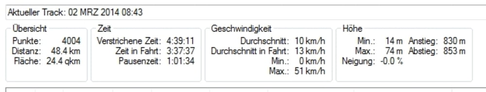
Minimum height 14 m
Maximum height 74 m
More about the tour author
|
|
sachsenwaldpioniere |
Comments

Start Reinbek, Schatzkammer
GPS tracks
Trackpoints-
GPX / Garmin Map Source (gpx) download
-
TCX / Garmin Training Center® (tcx) download
-
CRS / Garmin Training Center® (crs) download
-
Google Earth (kml) download
-
G7ToWin (g7t) download
-
TTQV (trk) download
-
Overlay (ovl) download
-
Fugawi (txt) download
-
Kompass (DAV) Track (tk) download
-
Track data sheet (pdf) download
-
Original file of the author (gpx) download
More about the tour author
|
|
sachsenwaldpioniere |
Add to my favorites
Remove from my favorites
Edit tags
Open track
My score
Rate