Login

Forgotten password?

Cookies have to be accepted!
Your browser's cookie functionality is disabled. Please enable this functionality.

Not a member yet?

Register now
Login

Available for registred users only

Log in to use this feature.

Forgotten password?

Cookies have to be accepted!
Your browser's cookie functionality is disabled. Please enable this functionality.

Not a member yet?

Register now
Filter
Categories
Advanced filters
  • Distance (km)
  • Height
Save filters Reset filter

TrackRank

QRCode

Technical data

Distance44,2 km Height666 m Way down663 m Duration00:00 h:m Date27.05.2005
Scores Author User Landscape Fun factor Fitness Technique

Statistics

5456 Views 2 Scores 671 Downloads 4.00 Average
Rate
  • Track data sheet
  • Directions
  • Downloads
Start an der S-Bahn bei Weiler (vor Schorndorf). Sehr schöne Tour durch viel Wald und fast ohne Autos. Tolle Anstiege und zwei schöne Möglichkeiten für ein Radler.

Tour gallery

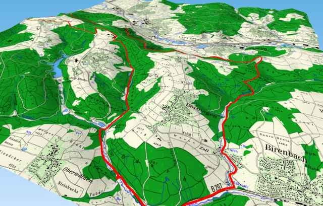
Tour map and elevation profile

  • Open Street Map
  • Google
Minimum height 242 m Maximum height 512 m Detailed view

More about the tour author

Marquinhos
Member since 2005

Send private message

Comments

Gideon on 29.04.2008

Nähe

Als ich bin die Stecke noch nicht gefahren aber kenne mich da gut aus also die landschaft ist zu empfehlen. Mein Problem ist ich möchte von Plüderhausen nach Adelberg und suche schon die ganze Zeit eine Karte im Internet wo ALLE Wege eingezeichnet sind da bei Plüderhausen einige Wanderwege fehlen die ich kenne und denke das vor Adelberg beim Zigelhau auch eine Str. oder ein Weg lang führt aber auf keiner karte bis jetzt gesehen und bei Google Erath is nur zu ahnen das da ein weg lang führt. Könnte sich ja jemand melden unter der E-Mail: Gideon.Mueller2007@gmx.de


Mfg Gideon

GPS tracks

Trackpoints
  • GPX / Garmin Map Source (gpx) download
  • TCX / Garmin Training Center® (tcx) download
  • CRS / Garmin Training Center® (crs) download
  • Google Earth (kml) download
  • G7ToWin (g7t) download
  • TTQV (trk) download
  • Overlay (ovl) download
  • Fugawi (txt) download
  • Kompass (DAV) Track (tk) download
  • Track data sheet (pdf) download
  • Original file of the author (g7t) download

More about the tour author

Marquinhos
Member since 2005

Send private message
Share track
Add to my favorites
Remove from my favorites
Edit tags
My score
Rate
Track: Weiler bei Schorndorf - Plüderhausen - Birenbach - Adelberg - Oberberken - Weiler
Type: Mountain bike
Distance: 44,2 km
Evaluated on:
Duration:
Day(s)
Hour(s)
Minute(s)
Score: Landscape Fun factor Fitness Technique