


Rureifel-Cross :: Mountainbiketour von Blankenheim nach Langerwehe
Ausgangspunkt ist der Bahnhof Blankenheim-Wald an der Eifellinie Köln-Trier. Die Rückfahrt von Langerwehe kann ebenfalls mit der Bahn erfolgen.
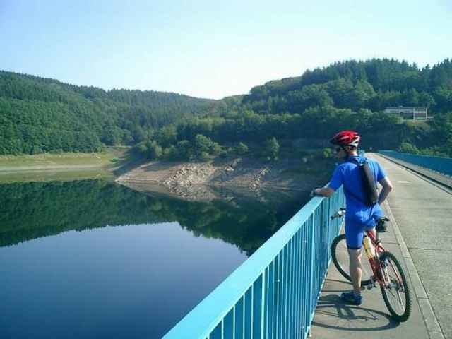
Gestartet am Bahnhof Blankenheim-Wald, geht es gleich einen feinen Singletrail hinauf. Das noch feuchte Gras weckt die letzten müden Lebensgeister und nach einer knackigen Steigung hoch zum Hauptweg sind wir schon wieder voll im Element.
Wir folgen vorerst der Beschilderung des Eifelsteig. Diesen kenne ich noch von der Eifelsteigtour und habe das meiste auch noch ganz gut in Erinnerung. Es geht über Wildenburg nach Hellenthal und hinauf zur Oleftalsperre. Bis jetzt ging es relativ gemächlich über weitgehend breite Forstwege, die gelegentlich durch Singletrails unterbrochen werden...
weiter auf http://www.xcracer.de/stre04_rureifelcross.htm
Ausgangspunkt ist der Bahnhof Blankenheim-Wald an der Eifellinie Köln-Trier. Die Rückfahrt von Langerwehe kann ebenfalls mit der Bahn erfolgen.
Gestartet am Bahnhof Blankenheim-Wald, geht es gleich einen feinen Singletrail hinauf. Das noch feuchte Gras weckt die letzten müden Lebensgeister und nach einer knackigen Steigung hoch zum Hauptweg sind wir schon wieder voll im Element.
Wir folgen vorerst der Beschilderung des Eifelsteig. Diesen kenne ich noch von der Eifelsteigtour und habe das meiste auch noch ganz gut in Erinnerung. Es geht über Wildenburg nach Hellenthal und hinauf zur Oleftalsperre. Bis jetzt ging es relativ gemächlich über weitgehend breite Forstwege, die gelegentlich durch Singletrails unterbrochen werden...
weiter auf http://www.xcracer.de/stre04_rureifelcross.htm
Further information at
http://www.xcracer.de/stre04_rureifelcross.htmTour gallery
Tour map and elevation profile
Minimum height 132 m
Maximum height 628 m
More about the tour author

|
XCRacer |
Comments
Autobahn A4 - Abfahrt Langerwehe
Beschilderung Langerwehe / Bahnhof folgen
Beschilderung Langerwehe / Bahnhof folgen
GPS tracks
Trackpoints-
GPX / Garmin Map Source (gpx) download
-
TCX / Garmin Training Center® (tcx) download
-
CRS / Garmin Training Center® (crs) download
-
Google Earth (kml) download
-
G7ToWin (g7t) download
-
TTQV (trk) download
-
Overlay (ovl) download
-
Fugawi (txt) download
-
Kompass (DAV) Track (tk) download
-
Track data sheet (pdf) download
More about the tour author
|
|
XCRacer |
Add to my favorites
Remove from my favorites
Edit tags
Open track
My score
Rate
Nordeifel-Cross
Hier der Film: http://video.google.de/videoplay?docid=8297786359755884944&hl=de