


Rif. Fabbro-Laggio-Lorenzago-Lago di Cadore-Pieve-
Vodo-Rif. Talamini-Forcella Val d'inferno-Forcella Deona-
Malga Deona-Forno di Zoldo
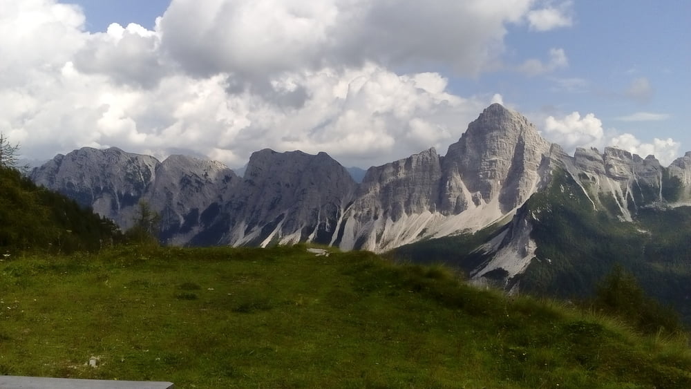
Start auf 1800m Seehöhe bei herrlichem Wetter und unglaublichem Panorama! Straße 1100hm runter - die Bremsen passen wieder! Die Cadore Seen beeindrucken. Dann bin ich zunächst auf der sehr betriebsamen strada statale unterwegs - nicht lustig. Erst nach Pieve finde ich auf den Radweg, der sehr angenehm zu fahren ist.. Von Vodo geht’s dann wieder eine teils sehr steile Straße hinauf (kein Verkehr!). Tw geschoben. Ab dem Rif Talamini geht’s auf einen Fußweg ca 500hm, wo manches Mal sogar das Schieben schwierig wird. 100hm unterm Forc. Deona trifft der Weg auf eine Schotterstraße, die auf meiner Karte leider nicht verzeichnet ist. Auf dem Joch bietet sich ein grandioser Anblick auf die Dolomiten! Auf Schotter, manchmal geteert wieder 1100 hm runter. In Forno gleich ein gutes Quartier gefunden und einen Supermarkt, um den reiseproviant wieder aufzufüllen. Quartier B&B Ai Lali NF 40 €, sehr gut.http://www.ailali.it/
Start auf 1800m Seehöhe bei herrlichem Wetter und unglaublichem Panorama! Straße 1100hm runter - die Bremsen passen wieder! Die Cadore Seen beeindrucken. Dann bin ich zunächst auf der sehr betriebsamen strada statale unterwegs - nicht lustig. Erst nach Pieve finde ich auf den Radweg, der sehr angenehm zu fahren ist.. Von Vodo geht’s dann wieder eine teils sehr steile Straße hinauf (kein Verkehr!). Tw geschoben. Ab dem Rif Talamini geht’s auf einen Fußweg ca 500hm, wo manches Mal sogar das Schieben schwierig wird. 100hm unterm Forc. Deona trifft der Weg auf eine Schotterstraße, die auf meiner Karte leider nicht verzeichnet ist. Auf dem Joch bietet sich ein grandioser Anblick auf die Dolomiten! Auf Schotter, manchmal geteert wieder 1100 hm runter. In Forno gleich ein gutes Quartier gefunden und einen Supermarkt, um den reiseproviant wieder aufzufüllen. Quartier B&B Ai Lali NF 40 €, sehr gut.http://www.ailali.it/
Tour gallery

Tour map and elevation profile
Minimum height 692 m
Maximum height 2053 m
More about the tour author
|
|
mitter |
Comments

Start beim Rifugio Fabbro in der Nähe vom Sella di Razzo.
GPS tracks
Trackpoints-
GPX / Garmin Map Source (gpx) download
-
TCX / Garmin Training Center® (tcx) download
-
CRS / Garmin Training Center® (crs) download
-
Google Earth (kml) download
-
G7ToWin (g7t) download
-
TTQV (trk) download
-
Overlay (ovl) download
-
Fugawi (txt) download
-
Kompass (DAV) Track (tk) download
-
Track data sheet (pdf) download
-
Original file of the author (gpx) download
More about the tour author
|
|
mitter |
Add to my favorites
Remove from my favorites
Edit tags
Open track
My score
Rate