


Hermagor-Garnitzenalm-Garnitzen Bergstation-Nassfeldpass-
Tröpolacher Alm-bei Rattendorfer Alm-Rattendorf-Hermagor
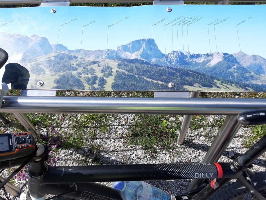
Sehr gute Auffahrt zur Garnitzenalm gefunden, nur am Ende bin ich doch wieder in der Sackgasse gelandet (Stopp Wegpunkt). Es empfiehlt sich vorher den oberen Weg zu nehmen. Nach der Garnitzenalm bin ich noch weiter rauf auf der offiziellen MTB Route zur Berstation vom 6er Kabinenlidft La Prima. Darüber (1900 m) gibt es einen wunderbaren Rundumblick sogar bis zum Großglockner. Bis zur Tröpolacher Alm gibt es dann doch noch einige hm! Kurz vor der Rattendorfer Alm Schotterstraße muss man noch eine kurze Schiebepassage abwärts in Kauf nehmen. Eine tolle Tour!
Sehr gute Auffahrt zur Garnitzenalm gefunden, nur am Ende bin ich doch wieder in der Sackgasse gelandet (Stopp Wegpunkt). Es empfiehlt sich vorher den oberen Weg zu nehmen. Nach der Garnitzenalm bin ich noch weiter rauf auf der offiziellen MTB Route zur Berstation vom 6er Kabinenlidft La Prima. Darüber (1900 m) gibt es einen wunderbaren Rundumblick sogar bis zum Großglockner. Bis zur Tröpolacher Alm gibt es dann doch noch einige hm! Kurz vor der Rattendorfer Alm Schotterstraße muss man noch eine kurze Schiebepassage abwärts in Kauf nehmen. Eine tolle Tour!
Tour gallery
Tour map and elevation profile
Minimum height 580 m
Maximum height 1901 m
More about the tour author
|
|
mitter |
Comments

Start in Hermagor von einem Stadtparkplatz - gratis.
GPS tracks
Trackpoints-
GPX / Garmin Map Source (gpx) download
-
TCX / Garmin Training Center® (tcx) download
-
CRS / Garmin Training Center® (crs) download
-
Google Earth (kml) download
-
G7ToWin (g7t) download
-
TTQV (trk) download
-
Overlay (ovl) download
-
Fugawi (txt) download
-
Kompass (DAV) Track (tk) download
-
Track data sheet (pdf) download
-
Original file of the author (gpx) download
More about the tour author
|
|
mitter |
Add to my favorites
Remove from my favorites
Edit tags
Open track
My score
Rate