
")

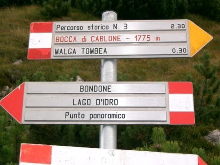
Von Vesio gehts erstmal Richtung Molkerei Alpe del Garda, dann weiter auf Teer bis Gardola. Hier kommt dann der steile Teeruphill zum Rifugio Piemp! Herrlich Tiefblicke zum Lago sind von dort garantiert. Im Rifugio kann man nur Getränke entnehmen! Über den Passo d'Ere und den Passo di Scarpape gehts in Valle di Campei. Dann kommt der Uphill zum Bocca di Cablone. Weiter gehts über die Malga Tombea zum Bocca di Campei. Danach muß kurz der Tunnel mit einer kurzen Tragepassage überwunden werden. Dann kommt der Downhill zur Malga di Lorina weiter gehts bis Downhill bis zum Wegdreieck (geradeaus gehts zum Tremalzo) und hier gehts rechts zum Valle San Michele. An der Molkerei Alpe del Garda kommen wir dann wieder an. Jetzt kurz zurück nach Vesio, wo man herrlich im Ristoranti am Dorfplatz seine Kohlenhydrat-Speicher nach dieser schweren Tour wieder füllen kann!
Further information at
http://www.hegibiketours.deTour gallery
Tour map and elevation profile
Minimum height 473 m
Maximum height 1868 m
More about the tour author
|
|
hegi |
Comments
Start auf dem Parkplatz in Vesio wo der Hubschrauber Landeplatz ist!
GPS tracks
Trackpoints-
GPX / Garmin Map Source (gpx) download
-
TCX / Garmin Training Center® (tcx) download
-
CRS / Garmin Training Center® (crs) download
-
Google Earth (kml) download
-
G7ToWin (g7t) download
-
TTQV (trk) download
-
Overlay (ovl) download
-
Fugawi (txt) download
-
Kompass (DAV) Track (tk) download
-
Track data sheet (pdf) download
-
Original file of the author (gpx) download
More about the tour author
|
|
hegi |
Add to my favorites
Remove from my favorites
Edit tags
Open track
My score
Rate
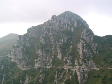
Landschaftliche Spitze.
Fahrspaß garantiert.
Die 2400 hm stimmen auch in etwa und sind relativ leicht zu treten.
Die ersten 20 Km sind auf Teerstrassen, was aber nicht störend ist. Später ist man wirklich in der "Pampa". Wir sind auf der ganzen tour keinen anderen Bikern begegnet.
Alles in allem eine gelungene Tour die man weiterempfehlen kann.
MTB Caplone