


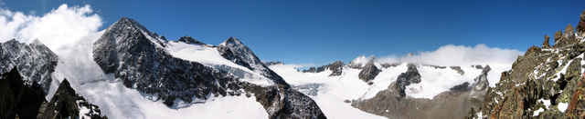
Schoene Tour mit traumhaften Ausblicken besonders von der Inneren Sommerwand aus, aber auch von der Vorderen Sommerwand aus hat man einen netten Ausblick. Auf- und Abstieg zur Inneren Sommerwand ueber den Sommerwandferner, d.h. hier ist die komplette Gletscherausruestung noetig. Der Gletscher ist unterhalb ca. 2850m auf der Gletscherhaelfte unterhalb der Kaeulscharte spaltenfrei. Ab knapp 2900m fangen Spalten an, die meisten sind aber eher klein (aber trotzdem sollte man wissen, wie man jemanden ggf. wieder aus einer Spalte herausbekommt...). Im Fels oberhalb des Gletschers sind Fixseile zum Gipfel der Inneren Sommerwand angebracht.
Der Weg zur Vorderen Sommerwand (optional) ist wesendlich einfacher und ohne Gletscher zu machen.
Trackfile copyright under Creative Commons (By attribution, share alike). See: http://creativecommons.org/licenses/by-sa/2.5/
Karte: DAV 31/1 (Stubaier Alpen / Hochstubai)
Der Weg zur Vorderen Sommerwand (optional) ist wesendlich einfacher und ohne Gletscher zu machen.
Trackfile copyright under Creative Commons (By attribution, share alike). See: http://creativecommons.org/licenses/by-sa/2.5/
Karte: DAV 31/1 (Stubaier Alpen / Hochstubai)
Tour gallery
Tour map and elevation profile
Minimum height 2145 m
Maximum height 3122 m
More about the tour author

|
Comments

Franz Senn Huette, 2147m, http://www.franzsennhuette.at
Aufstieg siehe Tour 2110: "Aufstieg zur Franz Senn Huette"
Anfahrt: Innsbruck, Brenner-Autobahn, Abfahrt Stubaital. Dann nach Neustift, Milders, Sedugg, Obberiesalm.
Aufstieg siehe Tour 2110: "Aufstieg zur Franz Senn Huette"
Anfahrt: Innsbruck, Brenner-Autobahn, Abfahrt Stubaital. Dann nach Neustift, Milders, Sedugg, Obberiesalm.
GPS tracks
Trackpoints-
GPX / Garmin Map Source (gpx) download
-
TCX / Garmin Training Center® (tcx) download
-
CRS / Garmin Training Center® (crs) download
-
Google Earth (kml) download
-
G7ToWin (g7t) download
-
TTQV (trk) download
-
Overlay (ovl) download
-
Fugawi (txt) download
-
Kompass (DAV) Track (tk) download
-
Track data sheet (pdf) download
-
Original file of the author (g7t) download
More about the tour author
|
|
Add to my favorites
Remove from my favorites
Edit tags
Open track
My score
Rate