Login

Forgotten password?

Cookies have to be accepted!
Your browser's cookie functionality is disabled. Please enable this functionality.

Not a member yet?

Register now
Login

Available for registred users only

Log in to use this feature.

Forgotten password?

Cookies have to be accepted!
Your browser's cookie functionality is disabled. Please enable this functionality.

Not a member yet?

Register now
Filter
Categories
Advanced filters
  • Distance (km)
  • Height
Save filters Reset filter

TrackRank

QRCode

Technical data

Distance36,8 km Height206 m Way down258 m Duration02:00 h:m Date06.09.2008
Scores Author Landscape Fun factor Fitness Technique

Statistics

500 Views Scores 47 Downloads Average
Rate
  • Track data sheet
  • Directions
  • Downloads

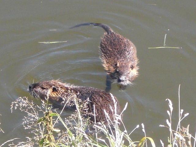
Absolutes Genußradeln. Herrliche Landschaft, sehr schöner Radweg, durchweg aspaltiert. Man kann an der Elster Nutrias beobachten (wenn man Glück hat) . Zwei Minigolfanlagen laden zum spielen ein.


Tour gallery

Tour map and elevation profile

  • Open Street Map
  • Google
Minimum height 178 m Maximum height 280 m Detailed view

More about the tour author

Bruno58

Comments

GPS tracks

Trackpoints
  • GPX / Garmin Map Source (gpx) download
  • TCX / Garmin Training Center® (tcx) download
  • CRS / Garmin Training Center® (crs) download
  • Google Earth (kml) download
  • G7ToWin (g7t) download
  • TTQV (trk) download
  • Overlay (ovl) download
  • Fugawi (txt) download
  • Kompass (DAV) Track (tk) download
  • Track data sheet (pdf) download
  • Original file of the author (gpx) download

More about the tour author

Bruno58

Share track
Add to my favorites
Remove from my favorites
Edit tags
My score
Rate
Track: Gera Langenberg -Ronneburg und zurück
Type: Trekkingbike
Distance: 36,8 km
Evaluated on:
Duration:
Day(s)
Hour(s)
Minute(s)
Score: Landscape Fun factor Fitness Technique