


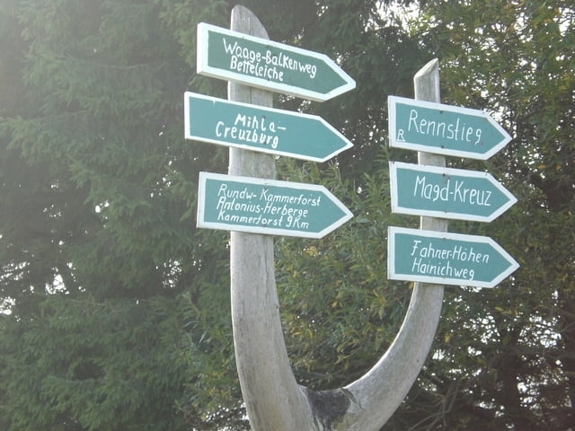
Die Wanderung beginnt in Kammerforst am Parkplatz Sportplatz.. Von hier geht es über die "Kugel" am Seebacher Forsthaus vorbei. Wir folgen der Beschilderung Waagebalkenweg und Fahner-Höhen Hainichweg. Wir überqueren die L1016 und erreichen als nächstes Ziel den "Lehdeborn". Über Holzstufen geht es bergab in das Langulaer Tal. Der Weg führt uns zum Waldrand und gibt den Blick frei auf Oberdorla. Vorbei am Wildgehege und am Waldschlößchen erreichen wir die Waldgaststätte "Weißes Haus". Zum Ende der Wanderung erreichen wir die Popperöder Quelle.
Karten:
- Die Karte Freizeit im Naturpark Eichsfeld Hainich Werratal 6
Further information at
http://www.muehlhausen.deTour gallery


Tour map and elevation profile
Minimum height 219 m
Maximum height 345 m
More about the tour author

|
schneig |
Comments

- aus Richtung Eisenach und Mühlhausen über die L 1016
- in Langula abbiegen nach Kammerforst
-in Kammerforst gerade aus bis zum Ortsrand
-Parkmöglichkeit am Sportplatz
GPS tracks
Trackpoints-
GPX / Garmin Map Source (gpx) download
-
TCX / Garmin Training Center® (tcx) download
-
CRS / Garmin Training Center® (crs) download
-
Google Earth (kml) download
-
G7ToWin (g7t) download
-
TTQV (trk) download
-
Overlay (ovl) download
-
Fugawi (txt) download
-
Kompass (DAV) Track (tk) download
-
Track data sheet (pdf) download
-
Original file of the author (gpx) download
More about the tour author
|
|
schneig |
Add to my favorites
Remove from my favorites
Edit tags
Open track
My score
Rate