Login

Forgotten password?

Cookies have to be accepted!
Your browser's cookie functionality is disabled. Please enable this functionality.

Not a member yet?

Register now
Login

Available for registred users only

Log in to use this feature.

Forgotten password?

Cookies have to be accepted!
Your browser's cookie functionality is disabled. Please enable this functionality.

Not a member yet?

Register now
Filter
Categories
Advanced filters
  • Distance (km)
  • Height
Save filters Reset filter

TrackRank

QRCode

Technical data

Distance59,4 km Height351 m Way down329 m Duration02:10 h:m Date09.05.2006
Scores Author Landscape Fun factor Fitness Technique

Statistics

1132 Views 2 Scores 193 Downloads 4.50 Average
Rate
  • Track data sheet
  • Directions
  • Downloads
Schöner Rundkurs, erste Hälfte ist flach, ab Kelheim mit einigen Höhenmetern.
Dauer ca. 2:10 bei 27.3 Schnitt.

Tour gallery

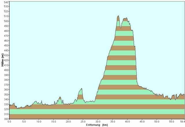
Tour map and elevation profile

  • Open Street Map
  • Google
Minimum height 321 m Maximum height 512 m Detailed view

More about the tour author

tobi_74

Comments

Ritzelschoner on 15.06.2012

Echt prima Feierabendrunde

Danke fürs Dokumentieren! Der geteerte Forstweg durch den Wald nördlich von Kehlheim ist ja traumhaft!

Falls der Weg etwas zu lang wird und es noch ein paar mehr Höhenmeter sein sollen, dann bietet sich die Abkürzung über Eilsbrunn nach Riegling an.
Startpunkt ist der Rennplatz in Regensburg, Ecke Roter-Brach-Weg, Franz-Von-Taxis-Ring.

GPS tracks

Trackpoints
  • GPX / Garmin Map Source (gpx) download
  • TCX / Garmin Training Center® (tcx) download
  • CRS / Garmin Training Center® (crs) download
  • Google Earth (kml) download
  • G7ToWin (g7t) download
  • TTQV (trk) download
  • Overlay (ovl) download
  • Fugawi (txt) download
  • Kompass (DAV) Track (tk) download
  • Track data sheet (pdf) download
  • Original file of the author (gpx) download

More about the tour author

tobi_74

Share track
Add to my favorites
Remove from my favorites
Edit tags
My score
Rate
Track: Regensburg - Poikam, Kelheim, Haugenried
Type: Road biking
Distance: 59,4 km
Evaluated on:
Duration:
Day(s)
Hour(s)
Minute(s)
Score: Landscape Fun factor Fitness Technique