Login

Forgotten password?

Cookies have to be accepted!
Your browser's cookie functionality is disabled. Please enable this functionality.

Not a member yet?

Register now
Login

Available for registred users only

Log in to use this feature.

Forgotten password?

Cookies have to be accepted!
Your browser's cookie functionality is disabled. Please enable this functionality.

Not a member yet?

Register now
Filter
Categories
Advanced filters
  • Distance (km)
  • Height
Save filters Reset filter

TrackRank

QRCode

Technical data

Distance53,2 km Height275 m Way down277 m Duration02:00 h:m Date20.06.2009
Scores Author Landscape Fun factor Fitness Technique

Statistics

1022 Views 1 Score 88 Downloads 4.00 Average
Rate
  • Track data sheet
  • Directions
  • Downloads
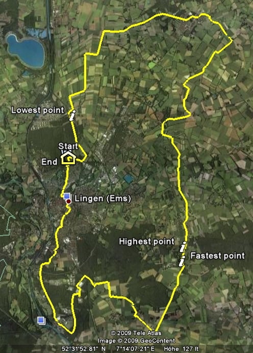
Einfache Tour um Lingen und vorbei am Kern- und Gaskraftwerk, bei der man aufgrund von starken Winden in dem flachen Emsland schon einmal auf den Zaehnen knischen kann.

Further information at

http://www.lingen.de

Tour gallery

Tour map and elevation profile

  • Open Street Map
  • Google
Minimum height 39 m Maximum height 110 m Detailed view

More about the tour author

quik-mic
Member since 2009

Send private message

Comments

Immer dem Navo folgen.

GPS tracks

Trackpoints
  • GPX / Garmin Map Source (gpx) download
  • TCX / Garmin Training Center® (tcx) download
  • CRS / Garmin Training Center® (crs) download
  • Google Earth (kml) download
  • G7ToWin (g7t) download
  • TTQV (trk) download
  • Overlay (ovl) download
  • Fugawi (txt) download
  • Kompass (DAV) Track (tk) download
  • Track data sheet (pdf) download
  • Original file of the author (gpx) download

More about the tour author

quik-mic
Member since 2009

Send private message
Share track
Add to my favorites
Remove from my favorites
Edit tags
My score
Rate
Track: Lingen-Kraftwerksrunde
Type: Road biking
Distance: 53,2 km
Evaluated on:
Duration:
Day(s)
Hour(s)
Minute(s)
Score: Landscape Fun factor Fitness Technique