


Eine geniale Feierabendrunde! Schöner Weg, einsam im Bereich des Tourzieles (Lechneralm). Viele Schöne Blicke auf das Inntal. Neben guter Aussicht auf der abwechslungsreichen Forststrasse gibt es auch schöne Trailabschnitte. Sehr gute Hütte!
Auffahrt wie zu Schuhbräualm am Internat vorbei. In der unteren Hälfte meist Teerstrasse mit ein paar steilen, längeren Stellen. Zum Tourziel hin immer offener und mit schönen Blicken.
Abfahrt: Bei dem Abzweig, 100hm unter der Lechneralm, geht es gleich auf einen geilen Wiesentrail. Dann über abwechslungsreiche Forstwege am Breitenberghaus vorbei. Zum Schluss nochmals durch nette Wege oberhal von Brannenburg. Abfahrt ist ziemlich vollgas möglich!
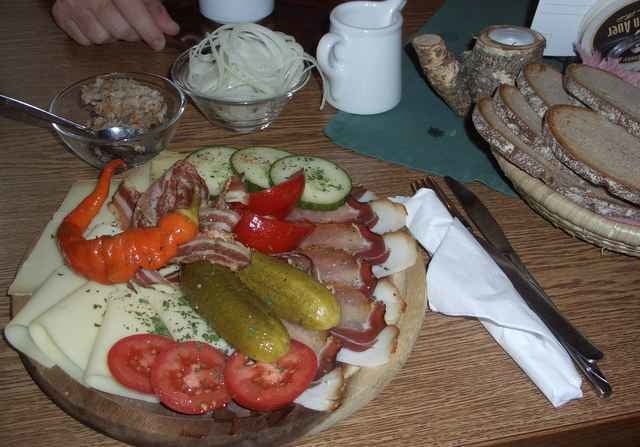
Einkehr: Lechneralm nur spontan bewirtschaftet, Breitberghaus mit sehr guter Brotzeit und nettem Wirtspaar.
Auffahrt wie zu Schuhbräualm am Internat vorbei. In der unteren Hälfte meist Teerstrasse mit ein paar steilen, längeren Stellen. Zum Tourziel hin immer offener und mit schönen Blicken.
Abfahrt: Bei dem Abzweig, 100hm unter der Lechneralm, geht es gleich auf einen geilen Wiesentrail. Dann über abwechslungsreiche Forstwege am Breitenberghaus vorbei. Zum Schluss nochmals durch nette Wege oberhal von Brannenburg. Abfahrt ist ziemlich vollgas möglich!
Einkehr: Lechneralm nur spontan bewirtschaftet, Breitberghaus mit sehr guter Brotzeit und nettem Wirtspaar.
Further information at
http://www.martin-blum.de/bikeTour gallery
Tour map and elevation profile
Minimum height 492 m
Maximum height 1266 m
More about the tour author
|
|
martin.blum |
Comments
A93, Inntal, Ausfahrt Brannenburg. In Brannenburg rechts und zum alten Friedhof beim Internat.
GPS tracks
Trackpoints-
GPX / Garmin Map Source (gpx) download
-
TCX / Garmin Training Center® (tcx) download
-
CRS / Garmin Training Center® (crs) download
-
Google Earth (kml) download
-
G7ToWin (g7t) download
-
TTQV (trk) download
-
Overlay (ovl) download
-
Fugawi (txt) download
-
Kompass (DAV) Track (tk) download
-
Track data sheet (pdf) download
-
Original file of the author (gpx) download
More about the tour author
|
|
martin.blum |
Add to my favorites
Remove from my favorites
Edit tags
Open track
My score
Rate
geniale Tour