


This is a smoker, since you spend a good 60-90 minutes riding non-stop upill (540m). The whole route is very steep and can be technical.
The downhill is absolutely insane...so much fun. This is easily the best downhill section in the area, and is even more fun at night with lights (don't sue me). Pretty much the entire route is rideable, but some sections are a right on the verge and most people will walk those bits (very short little sections).
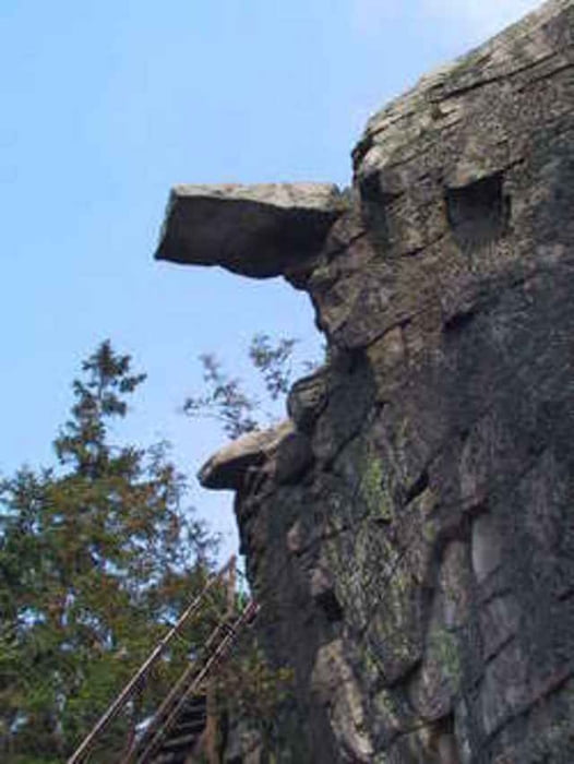
The Saubadfelsen is a cool rock formation that you can walk up to the top of, and the Platte (at 958m) is ythe highest peak in the area, and has a huge fire-tower you can walk up and you'll get a great view out to Weiden, Czech, etc...
---------------------------------------------------------
Eine gute stunde bis 90min bergauf(540hm ohne pause)...sehr steil und technich (540hm in 7 km)schone Steinformationen und Klippen, und jede menge spass downhill. Schonsten bergab im diesen Bereich. Nur ein paar meter sind absolute unfahrbar, aber es gibts viele technich passagen das die meisten schieben werden (aber die sind moeglich).
Die Saubadfelsen sind schon and die Platte (958m) gibts ein wunderschon ausblick uber de Oberpfalz.
Absolut highlight diesen Bereich. Tour ist Hin und Zuruck von Parkplatz bis Platte (958m) und zuruck.
The downhill is absolutely insane...so much fun. This is easily the best downhill section in the area, and is even more fun at night with lights (don't sue me). Pretty much the entire route is rideable, but some sections are a right on the verge and most people will walk those bits (very short little sections).
The Saubadfelsen is a cool rock formation that you can walk up to the top of, and the Platte (at 958m) is ythe highest peak in the area, and has a huge fire-tower you can walk up and you'll get a great view out to Weiden, Czech, etc...
---------------------------------------------------------
Eine gute stunde bis 90min bergauf(540hm ohne pause)...sehr steil und technich (540hm in 7 km)schone Steinformationen und Klippen, und jede menge spass downhill. Schonsten bergab im diesen Bereich. Nur ein paar meter sind absolute unfahrbar, aber es gibts viele technich passagen das die meisten schieben werden (aber die sind moeglich).
Die Saubadfelsen sind schon and die Platte (958m) gibts ein wunderschon ausblick uber de Oberpfalz.
Absolut highlight diesen Bereich. Tour ist Hin und Zuruck von Parkplatz bis Platte (958m) und zuruck.
Tour gallery
Tour map and elevation profile
Minimum height 537 m
Maximum height 958 m
More about the tour author
|
|
adamschlang |
Comments

Small parkplats near Beringersreuth (2-3km from Erbendorf). Only about 15-20min from Grafenwoehr.
Kleine Parkplaz bei Beringersreuth (2-3km von Erbendorf)
Kleine Parkplaz bei Beringersreuth (2-3km von Erbendorf)
GPS tracks
Trackpoints-
GPX / Garmin Map Source (gpx) download
-
TCX / Garmin Training Center® (tcx) download
-
CRS / Garmin Training Center® (crs) download
-
Google Earth (kml) download
-
G7ToWin (g7t) download
-
TTQV (trk) download
-
Overlay (ovl) download
-
Fugawi (txt) download
-
Kompass (DAV) Track (tk) download
-
Track data sheet (pdf) download
-
Original file of the author (gpx) download
More about the tour author
|
|
adamschlang |
Add to my favorites
Remove from my favorites
Edit tags
Open track
My score
Rate