


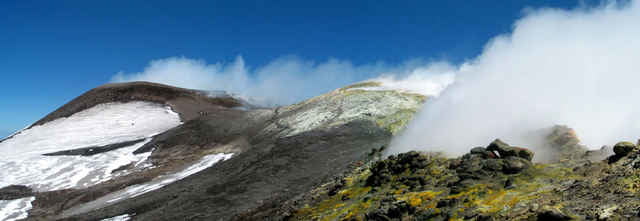
Aufstieg von der oberen Seilbahnstation zu den Hauptkratern des Ätna. Zunächst auf den derzeit höchsten Punkt (Nord Ost Krater) dann Abstieg und weiter zur Voragine und entlang der Bocca Nuova 1 und 2 wieder hinunter zur Seilbahn.
Es wird nicht empfohlen dieser Route zu folgen, da aufgrund der Wind- (Wetter-)situation, die die Gase der Hauptkrater in südöstlicher Richtung trieb, die Hauptkrater zunächst westlich umgangen werden mussten. Der Aufstieg erfolgte daher eher von nord-westlicher Richtung. Empfehlenswert ist ein Aufstieg von Süden, falls möglich. Um dies herauszufinden, wenden sie sich am besten an einen Vulkanführer des Ätna und schliessen sich ggf. einer geführten Tour an. Dadurch haben sie die größten Chancen diese grandiose Gipfellandschaft erreichen zu können.
Achtung: Aufgrund plötzlich auftretender starker vulkansicher Tätigkeit und Wetterwechsel ist es ratsam die Tour nur mit erfahrenen und autorisierten Bergführern zu unternehmen!
Ich kann folgende Bergführer empfehlen (s.u.):
Attention: Due to suddenly appearing volcanic activity and weather changes it is highly advisable to do this tour with an experienced and authorised volcano guide.
I could recommend the following guids:
Andrea Ercolani
Guida Vulcanologica C.R.G.A.V.S
tel&fax +39 095 968 882
mob. +39 348 85 30 310
http://www.siciltrek.it
or
Etna Trekking
Pizza Santo Cali, 4
95015 Linguglossa (CT)
Tel./Fax: 095 64 78 77
info@etnatrekking.it
Play save on any volcano!
Tour gallery
Tour map and elevation profile
Minimum height 1881 m
Maximum height 3328 m
More about the tour author

|
Thomas2Reichart |
Comments

Chris
on 19.07.2007
how long does the tour take in hours?
Von Catania zum Refugio Sapienza (Etna Süd)
GPS tracks
Trackpoints-
GPX / Garmin Map Source (gpx) download
-
TCX / Garmin Training Center® (tcx) download
-
CRS / Garmin Training Center® (crs) download
-
Google Earth (kml) download
-
G7ToWin (g7t) download
-
TTQV (trk) download
-
Overlay (ovl) download
-
Fugawi (txt) download
-
Kompass (DAV) Track (tk) download
-
Track data sheet (pdf) download
-
Original file of the author (gpx) download
More about the tour author
|
|
Thomas2Reichart |
Add to my favorites
Remove from my favorites
Edit tags
Open track
My score
Rate