Login

Login oublié ?

Cookies have to be accepted!
Your browser's cookie functionality is disabled. Please enable this functionality.

Not a member yet?

Register now
Login

Available for registred users only

Log in to use this feature.

Login oublié ?

Cookies have to be accepted!
Your browser's cookie functionality is disabled. Please enable this functionality.

Not a member yet?

Register now
Filter
Catégories
Advanced filters
  • Longueur (km)
  • Altimètre
Enregistrer le filtre Reset filter

TrackRank

QRCode

Technical data

Longueur43,5 km Altimètre913 m Way down910 m Durée03:00 h:m Date26.05.2014
Evaluations Author User Paysage Aspect amusement Condition Technique

Statistiques

920 Vues 1 Evaluation 241 Téléchargements 5.00 Moyenne
Rate
  • Feuille de tours
  • Arrivée
  • Téléchargements

Gottenheim - Wasenweiler - Liliental - Lenzenberg - Kreuzbuck - Hochbuck - Blankenhornsberg - Achkarren - Schlossberg - Bitzenberg - Adlerhorst Sattel -Totenkopf - Neun Lindenturm - Vogelsangpass - Wächtelberg - Bötzingen - Gottenheim

Von Gottene, erschdmol nach Wasewiela. Die Strecke ist flach und führt dann in das abgelegene Liliental. Hier tolle Trails im Wald leicht steigend. Später ist die Landschaft etwas lichter und durch die fremden Bäume vielleicht etwas "skuril".

Am Lenzenberg hat man die Höhe erreicht. Weiter geht es über den Kreuzbuck zum Blankenhornsberg (Weingut). Vom Bömisch Berg aus hat man eine weite Einsicht in die Vogesen.

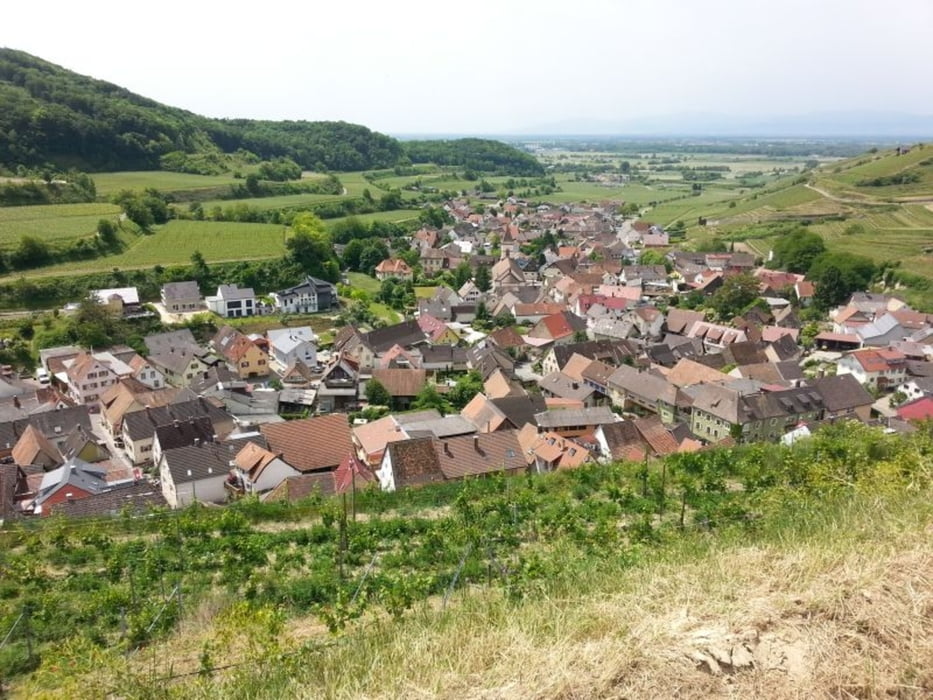
Nun wieder hinab durch Achkarren und wieder auf den Schlossberg hinauf. Dann den gemächlichen aber längeren Anstieg über den Bitzenberg, Adlerhorstsattel zum Totenkopf/Neunlindenturm. Von da bergab zum Vogelsangpass, Wächtelberg und dann nach Bötzingen. Nun noch zurück um Ausgangspunkt Gottenheim.

Further information at

http://de.wikipedia.org/wiki/Kaiserstuhl_%28Gebirge%29

Galerie du tour

Carte du tour et altitude

  • Open Street Map
  • Google
Minimum height 213 m Maximum height 573 m Vue de détail

More about the tour author

messer1
Member since 2011

Send private message

Commentaires

Startpunkt ist Gottenheim. Am Bahnhöfle gibt es ausreichend Parkmöglichkeiten. Alternativ kann man auch in Wasenweiler starten.

Mit öffentlichen Verkehrsmitteln sehr gut zu erreichen über Freiburg Hbf und dann mit dem Zug nach Breisach. Unterwegs in Gottenheim aussteigen nicht vergessen! 

:-)

Tracks GPS

Trackpoints
  • GPX / Garmin Map Source (gpx) download
  • TCX / Garmin Training Center® (tcx) download
  • CRS / Garmin Training Center® (crs) download
  • Google Earth (kml) download
  • G7ToWin (g7t) download
  • TTQV (trk) download
  • Overlay (ovl) download
  • Fugawi (txt) download
  • Kompass (DAV) Track (tk) download
  • Feuille de tours (pdf) download
  • Original file of the author (gpx) download

More about the tour author

messer1
Member since 2011

Send private message
Share track
Add to my favorites
Remove from my favorites
Edit tags
My score
Rate
Tour: Um den Kaiserstuhl
Cat.: Mountainbike
Longueur: 43,5 km
Evaluated on:
Durée:
Day(s)
Hour(s)
Minute(s)
Evaluation: Paysage Aspect amusement Condition Technique