


Ausgangspunkt großer Parkplatz in St. Ulrich a. P.
Straße überqueren, dem Gehweg entlang Richtung Norden bis zu kleiner Kapelle, hier nach links zum Waldrand - Kreuzwegstation bis St. Adolari- beliebte Walfahrtskirche mit ältestem Marienfresko Nordtirols- Einkehrmöglichkeit im
Tiroler Wirtshaus ST. Adolari (Dienstag Ruhetag)
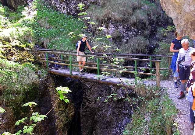
> an der Straße ca. 100m nach Norden über die Brücke zum kleinen Parkplatz- Aufstieg zur Teufelsklamm- sehr steil, das letzte Stück in der Klamm ist seilversichert- Vorsicht- von der Brücke einen schönen Blick in die Klamm, der Teufel grüßt Sie aus einer Felsnische-
Abstieg gleicher Weg bis zum Parkplatz- links entlang des Baches und des Seeufers zurück zum Parkplatz- in der Mitte des Weges Einkehrmöglichkeit.
Straße überqueren, dem Gehweg entlang Richtung Norden bis zu kleiner Kapelle, hier nach links zum Waldrand - Kreuzwegstation bis St. Adolari- beliebte Walfahrtskirche mit ältestem Marienfresko Nordtirols- Einkehrmöglichkeit im
Tiroler Wirtshaus ST. Adolari (Dienstag Ruhetag)
> an der Straße ca. 100m nach Norden über die Brücke zum kleinen Parkplatz- Aufstieg zur Teufelsklamm- sehr steil, das letzte Stück in der Klamm ist seilversichert- Vorsicht- von der Brücke einen schönen Blick in die Klamm, der Teufel grüßt Sie aus einer Felsnische-
Abstieg gleicher Weg bis zum Parkplatz- links entlang des Baches und des Seeufers zurück zum Parkplatz- in der Mitte des Weges Einkehrmöglichkeit.
Further information at
http://www.landhotels.at/strasserwirtGalerie du tour
Carte du tour et altitude
Minimum height 730 m
Maximum height 943 m
More about the tour author

|
strasserwirt |
Commentaires

großer Parkplatz am Nordende von St. Ulrich a. P.(kostenlos)
von Waidring kommend Richtung Süden bei der Ortseinfahrt
von Fieberbrunn kommend durch den Ort, rechts
von Waidring kommend Richtung Süden bei der Ortseinfahrt
von Fieberbrunn kommend durch den Ort, rechts
Tracks GPS
Trackpoints-
GPX / Garmin Map Source (gpx) download
-
TCX / Garmin Training Center® (tcx) download
-
CRS / Garmin Training Center® (crs) download
-
Google Earth (kml) download
-
G7ToWin (g7t) download
-
TTQV (trk) download
-
Overlay (ovl) download
-
Fugawi (txt) download
-
Kompass (DAV) Track (tk) download
-
Feuille de tours (pdf) download
-
Original file of the author (g7t) download
More about the tour author
|
|
strasserwirt |
Add to my favorites
Remove from my favorites
Edit tags
Open track
My score
Rate