Inloggen

Login vergeten?

Cookies moeten worden aanvaard!
De cookiefunctie van uw browser is gedeactiveerd. Activeer de functie.

Ben je nog geen lid?

Registreer nu
Inloggen

Alleen mogelijk voor ingelogde gebruikers

Log in om deze functie te kunnen gebruiken.

Login vergeten?

Cookies moeten worden aanvaard!
De cookiefunctie van uw browser is gedeactiveerd. Activeer de functie.

Ben je nog geen lid?

Registreer nu
Filter
Categorieën
Geavanceerde filters
  • Lengte (km)
  • Hoogtemeter
Filter opslaan Filter resetten

TrackRank

QRCode

Technische gegevens

Lengte13,5 km Hoogtemeter142 m Afdaling641 m Duur05:00 h:m Datum08.04.2005
Beoordelingen Auteur Landschap Funfactor Conditie Techniek

Statistiek

6409 Views Beoordelingen 1050 Downloads Gemiddelde
Tarief
  • Pagina van de tocht
  • Route
  • Downloads
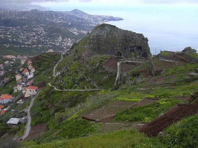
This is a walk in two parts, the first half is an easy walk from Estrieto de Camara de Lobos on the Levada do Norte, through the Ribiera da Caixa valley, and then onto the massive sea cliff of Cabo Girao.
This is the second highest sea cliff in Europe at 1902 feet sheer drop into the sea. The views to the east are amazing
The second part is a steep, knee wrenching descent by steps and road to the town of Camara de Lobos.
The GPS signal gets a bit confused at one point due to the geography, but this is during the Levada section so you cannot get lost.

Fotogalerie van de tocht

Kaart en hoogteprofiel van de tocht

  • Open Street Map
  • Google
Minimumhoogte 37 m Maximale hoogte 603 m Detailweergave

Meer over de tour auteur

SILVAED
Lid sinds 2005

Stuur een privébericht

Commentaren

The start point is at the village of Estreito de Camara de Lobos. You can take a number 96 bus from Funchal. The bus will stop about 600 mtr on from the church, with a sign across the road to the Levada do Norte.
The finish is in Camara de Lobos near the Taxi rank in front of the Harbour where you can get a refreshing beer and a return bus to Funchal

GPS-tracks

Trackpoints
  • GPX / Garmin Map Source (gpx) download
  • TCX / Garmin Training Center® (tcx) download
  • CRS / Garmin Training Center® (crs) download
  • Google Earth (kml) download
  • G7ToWin (g7t) download
  • TTQV (trk) download
  • Overlay (ovl) download
  • Fugawi (txt) download
  • Kompass (DAV) Track (tk) download
  • Pagina van de tocht (pdf) download
  • Origineel dossier van de auteur (g7t) download

Meer over de tour auteur

SILVAED
Lid sinds 2005

Stuur een privébericht
Share track
Toevoegen aan mijn favorieten
Uit mijn favorieten verwijderen
Tags bewerken
Mijn waardering
Tarief
Tocht: A Levada walk to Cabo Girau then onto Camara de Lobos
Type: Wandelen
Lengte: 13,5 km
Evaluated on:
Duur:
Dagen
Uurtjes
Minuten
Beoordeling: Landschap Funfactor Conditie Techniek