Login

Login vergessen?

Cookies müssen akzeptiert werden!
Die Cookie-Funktion Ihres Browsers ist deaktiviert. Bitte aktivieren Sie die Funktion.

Noch kein Mitglied?

Jetzt Registrieren
Login

Nur für eingeloggte Benutzer möglich

Melde dich an, um diese Funktion nutzen zu können.

Login vergessen?

Cookies müssen akzeptiert werden!
Die Cookie-Funktion Ihres Browsers ist deaktiviert. Bitte aktivieren Sie die Funktion.

Noch kein Mitglied?

Jetzt Registrieren
Filter
Kategorien
Erweiterte Filter
  • Länge (km)
  • Höhenmeter
Filter speichern Filter zurücksetzen

TrackRank

QRCode

Technische Daten

Länge61,6 km Höhenmeter1395 m Abstieg1395 m Dauer00:00 h:m Datum08.09.2014
Bewertungen Autor Landschaft Spaßfaktor Kondition Technik

Statistik

356 Views Bewertungen 31 Downloads Durchschnitt
Bewerten
  • Tourenblatt
  • Anfahrt
  • Downloads

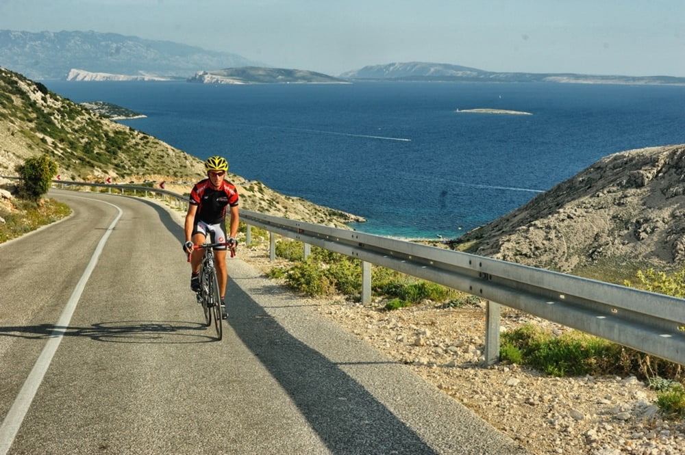
Interesantna ruta koja nije kružna već se vraća istim smjerom nazad. Vodi do Stare Baške, mjesta u blizini Baške međutim s jedinim cestovnim putem koji vodi preko Punta. Stara Baška je zanimljiva jer je na kraju “slijepog crijeva”, a jedna od posebnosti je neprometna cesta s lijepim vidicima na okolne otoke te mogućnošću kupanja na nekoj od plaža na ruti.

This is an interesting route which is not circular, but takes the same way back.
It leads you to Stara Baška, a town in close proximity to Baška but the only road will take you there through Punat. Stara Baška is interesting as it is at the very end of an “appendix” and what will definitely thrill you is a low-traffic road with wonderful views of the surrounding islands and it offers an opportunity to rest on one of the many beautiful beaches in the area, and along the route.

http://adriabike.hr
https://hotelibaska.hr


Tour Karte und Höhenprofil

  • Open Street Map
  • Google
Minimale Höhe 1 m Maximale Höhe 317 m Detailansicht

Mehr zum Tourautor

AdriaBikeHotels
Mitglied seit 2014

Land: Kroatien

60 erstellte Touren
7.2
Private Nachricht senden

Kommentare

GPS-Tracks

Trackpunkte
  • GPX / Garmin Map Source (gpx) download
  • TCX / Garmin Training Center® (tcx) download
  • CRS / Garmin Training Center® (crs) download
  • Google Earth (kml) download
  • G7ToWin (g7t) download
  • TTQV (trk) download
  • Overlay (ovl) download
  • Fugawi (txt) download
  • Kompass (DAV) Track (tk) download
  • Tourenblatt (pdf) download
  • Originaldatei des Autors (gpx) download

Mehr zum Tourautor

AdriaBikeHotels
Mitglied seit 2014

Land: Kroatien

60 erstellte Touren
7.2
Private Nachricht senden
Tour teilen
Zu meinen Favoriten hinzufügen
Von meinen Favoriten entfernen
Tags bearbeiten
Meine Bewertung
Bewerten
Tour: BAŠKA ROAD 2
Art: Rennrad
Länge: 61,6 km
Bewertet am:
Dauer:
Tag(e)
Stunde(n)
Minute(n)
Bewertung: Landschaft Spaßfaktor Kondition Technik