Login

Login vergessen?

Cookies müssen akzeptiert werden!
Die Cookie-Funktion Ihres Browsers ist deaktiviert. Bitte aktivieren Sie die Funktion.

Noch kein Mitglied?

Jetzt Registrieren
Login

Nur für eingeloggte Benutzer möglich

Melde dich an, um diese Funktion nutzen zu können.

Login vergessen?

Cookies müssen akzeptiert werden!
Die Cookie-Funktion Ihres Browsers ist deaktiviert. Bitte aktivieren Sie die Funktion.

Noch kein Mitglied?

Jetzt Registrieren
Filter
Kategorien
Erweiterte Filter
  • Länge (km)
  • Höhenmeter
Filter speichern Filter zurücksetzen

TrackRank

QRCode

Technische Daten

Länge20,1 km Höhenmeter546 m Abstieg501 m Dauer03:00 h:m Datum20.04.2009
Bewertungen Autor Landschaft Spaßfaktor Kondition Technik

Statistik

1796 Views Bewertungen 133 Downloads Durchschnitt
Bewerten
  • Tourenblatt
  • Anfahrt
  • Downloads
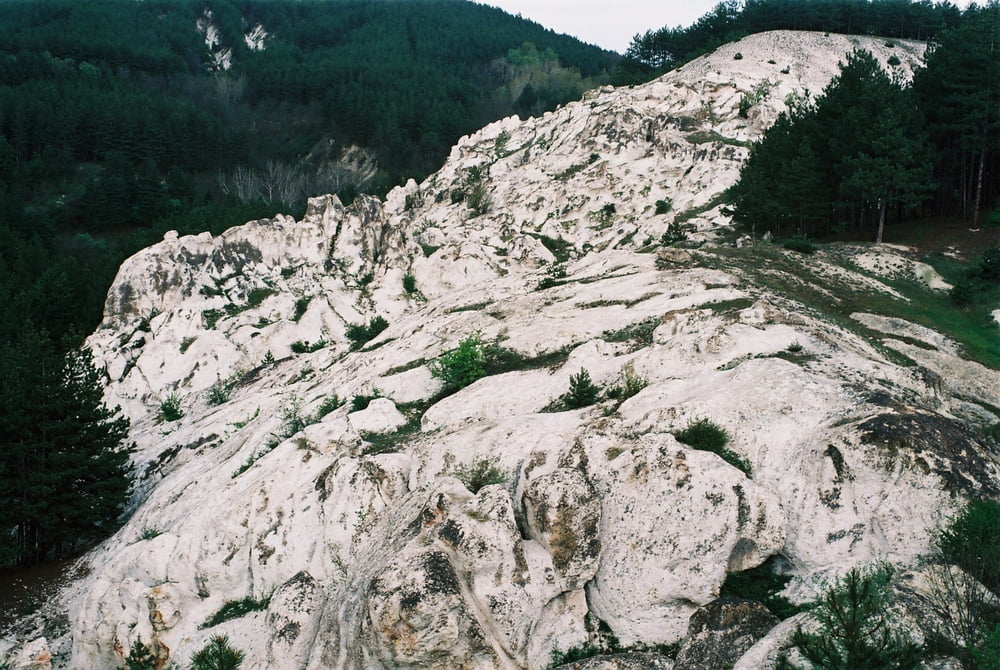
Leg 11 of the Trans Rhodopean Trail. From Kirdjali you follow the asphalt road in NE direction towards the rock phenomena called "The Stone Wedding". The tufa formations are located a couple of hundred meters to the left of the road so you have to push the bike if you want to see them. From "The Stone Wedding" you have to keep riding on the asphalt road in the direction of Povet and Panchevo. Just before you enter Panchevo you have to leave the asphalt and turn left - nice forest road trough the meadows starts from here. The next goal is to reach the village of Oreshnitsa located on the slopes of the hills in northern direction. At the top end of Oreshnitsa one must follow the road trough the open areas to reach the village of Bolyartsi. From this point to main aspahlt road from Murgovo to Perperikon is only downhill.

Weitere Informationen unter

http://rudopia.org

Tour Galerie

Tour Karte und Höhenprofil

  • Open Street Map
  • Google
Minimale Höhe 259 m Maximale Höhe 521 m Detailansicht

Mehr zum Tourautor

Pirateria
Mitglied seit 2008

Land: Bulgarien

57 erstellte Touren
6.6
Private Nachricht senden

Kommentare

GPS-Tracks

Trackpunkte
  • GPX / Garmin Map Source (gpx) download
  • TCX / Garmin Training Center® (tcx) download
  • CRS / Garmin Training Center® (crs) download
  • Google Earth (kml) download
  • G7ToWin (g7t) download
  • TTQV (trk) download
  • Overlay (ovl) download
  • Fugawi (txt) download
  • Kompass (DAV) Track (tk) download
  • Tourenblatt (pdf) download
  • Originaldatei des Autors (gpx) download

Mehr zum Tourautor

Pirateria
Mitglied seit 2008

Land: Bulgarien

57 erstellte Touren
6.6
Private Nachricht senden
Tour teilen
Zu meinen Favoriten hinzufügen
Von meinen Favoriten entfernen
Tags bearbeiten
Meine Bewertung
Bewerten
Tour: Kirdjali - Perperikon`
Art: Mountainbike
Länge: 20,1 km
Bewertet am:
Dauer:
Tag(e)
Stunde(n)
Minute(n)
Bewertung: Landschaft Spaßfaktor Kondition Technik