Login

Passwort vergessen?

Cookies müssen akzeptiert werden!
Die Cookie-Funktion Ihres Browsers ist deaktiviert. Bitte aktivieren Sie die Funktion.

Noch kein Mitglied?

Jetzt Registrieren
Login

Nur für eingeloggte Benutzer möglich

Melde dich an, um diese Funktion nutzen zu können.

Passwort vergessen?

Cookies müssen akzeptiert werden!
Die Cookie-Funktion Ihres Browsers ist deaktiviert. Bitte aktivieren Sie die Funktion.

Noch kein Mitglied?

Jetzt Registrieren
Filter
Kategorien
Erweiterte Filter
  • Länge (km)
  • Höhenmeter
Filter speichern Filter zurücksetzen

TrackRank

QRCode

Technische Daten

Länge14,5 km Höhenmeter99 m Abstieg468 m Dauer04:30 h:m Datum05.01.2010
Bewertungen Autor Landschaft Spaßfaktor Kondition Technik

Statistik

995 Views Bewertungen 179 Downloads Durchschnitt
Bewerten
  • Tourenblatt
  • Anfahrt
  • Downloads

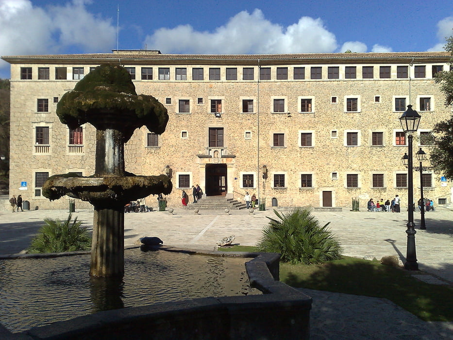
This is a simple trekking tour, since you go all the way downwards for 16 Km.  The monastery is a very beautiful building with a museum, a big garden and the chappel. There´s a restaurant and a bar next to the monastery. The monk Juniper Serra spent some years of his life here before he went to America, where he founded many cities in California, among them San Francisco and San Diego.

There are many small rocks for long sections on your way through the mointains, so pay attention to your feet. In some sections you have to walk along the highway, since there´s no other choice, so be very careful. There´s not much traffic but you never know.

Caimari is a small nest after the mountains where you can have something to eat and drink before you continue the walk. From this town to Selva you may walk along the highway thanks to a special road they built for hikers, walkers and inhabitants of both towns.

The road from Selva to Inca is optional, but as I mentioned you have to plan your trip, since there´s only one route and it runs a couple of times during the day. If you don´t catch the bus or if you have to wait 3 hours for the next bus, you walk around 2 Kms along the highway which means that you and drivers are in danger. There are secundary roads but they all go to east or west instead of south, so it takes long and the traffic might be as heavy.

After the horror walk (2 Km.) there´s a parallel road which takes you directly to Inca with no traffic (perhaps 1 horse from time to time).


Tour Galerie

Tour Karte und Höhenprofil

  • Open Street Map
  • Google
Minimale Höhe 163 m Maximale Höhe 591 m Detailansicht

Mehr zum Tourautor

alonso100
Mitglied seit 2008

Land: Deutschland

51 erstellte Touren
5.7
Private Nachricht senden

Kommentare

From Palma you travel by train to Inca and from there you go with a small shuttle to Lluc and its monastery. Unfortunately, the service is scarce, especially during the weekend or on holidays, so you better plan the trip beforehand.

The return either from Caimari or Selva to Inca is also a big problem due to the number of runs for the shuttle. From Inca you find normally every 30 min. a train to Palma.

GPS-Tracks

Trackpunkte
  • GPX / Garmin Map Source (gpx) download
  • TCX / Garmin Training Center® (tcx) download
  • CRS / Garmin Training Center® (crs) download
  • Google Earth (kml) download
  • G7ToWin (g7t) download
  • TTQV (trk) download
  • Overlay (ovl) download
  • Fugawi (txt) download
  • Kompass (DAV) Track (tk) download
  • Tourenblatt (pdf) download
  • Originaldatei des Autors (gpx) download

Mehr zum Tourautor

alonso100
Mitglied seit 2008

Land: Deutschland

51 erstellte Touren
5.7
Private Nachricht senden
Tour teilen
Zu meinen Favoriten hinzufügen
Von meinen Favoriten entfernen
Tags bearbeiten
Meine Bewertung
Bewerten
Tour: From Monastery in Lluc to Inca
Art: Wandern
Länge: 14,5 km
Bewertet am:
Dauer:
Tag(e)
Stunde(n)
Minute(n)
Bewertung: Landschaft Spaßfaktor Kondition Technik