Login

Forgot your login?

Cookies have to be accepted!
Your browser's cookie functionality is disabled. Please enable this functionality.

Not a member yet?

Register now
Login

Available for registred users only

Log in to use this feature.

Forgot your login?

Cookies have to be accepted!
Your browser's cookie functionality is disabled. Please enable this functionality.

Not a member yet?

Register now
Filter
Categories
Advanced filters
  • Distance (km)
  • Height
Save filters Reset filter

TrackRank

QRCode

Technical data

Distance22,5 km Height242 m Way down241 m Duration01:20 h:m Date15.01.2012
Scores Author Landscape Fun factor Fitness Technique

Statistics

323 Views Scores 3 Downloads Average
Rate
  • Track data sheet
  • Directions
  • Downloads

neděle 15.1.2012 po obědě, rozlehlý spot na SZ vítr,  chvílema přifouklo přes 10m/s, takže jsem si i přes suchý, tupý, pomalý sníh udělal rychlostní rekord - 58km/h...

... který mně po 14 dnech dostal na průběžnou bramborovou medajli

Tour gallery

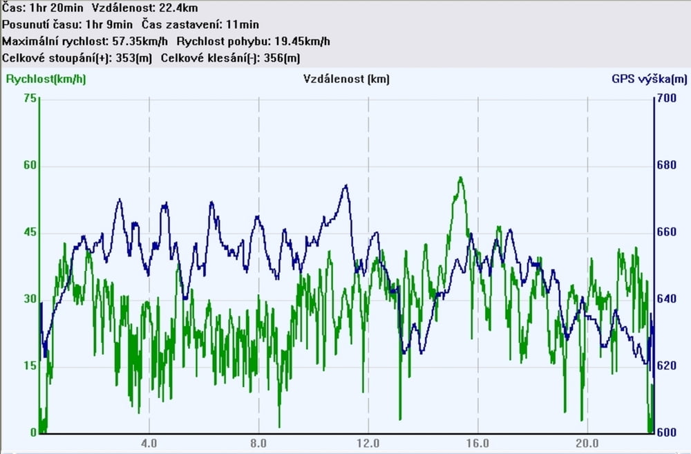
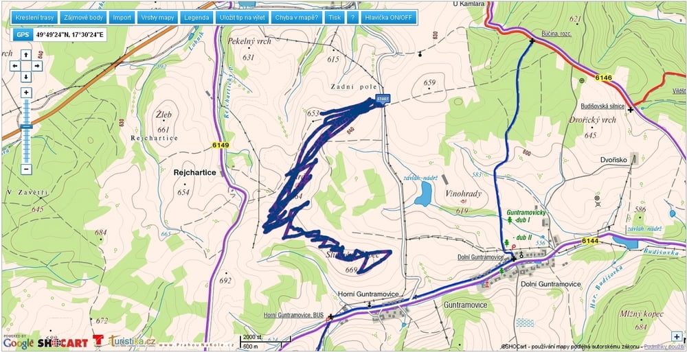
Tour map and elevation profile

  • Open Street Map
  • Google
Minimum height 614 m Maximum height 675 m Detailed view

More about the tour author

mtbBen
Member since 2011

Send private message

Comments

GPS tracks

Trackpoints
  • GPX / Garmin Map Source (gpx) download
  • TCX / Garmin Training Center® (tcx) download
  • CRS / Garmin Training Center® (crs) download
  • Google Earth (kml) download
  • G7ToWin (g7t) download
  • TTQV (trk) download
  • Overlay (ovl) download
  • Fugawi (txt) download
  • Kompass (DAV) Track (tk) download
  • Track data sheet (pdf) download
  • Original file of the author (gpx) download

More about the tour author

mtbBen
Member since 2011

Send private message
Share track
Add to my favorites
Remove from my favorites
Edit tags
My score
Rate
Track: kite Stráž
Type: Paragliding and hang gliding
Distance: 22,5 km
Evaluated on:
Duration:
Day(s)
Hour(s)
Minute(s)
Score: Landscape Fun factor Fitness Technique