


English follows German.
Dieses ist eine zweitägige Reise in den berühmten Oze Sumpflandbereich. Es gibt viele differen die Wege, die hier vorhanden sind, und Sie können Hyuchigatake auch klettern, aber wir didn't haben Zeit. Am ersten Tag kletterten wir von Oshimizu über Sanpei-touge (Pass) zu Oze-numa und blieben an der Chozo-goya Gebirgshütte. Dieses dauerte ungefähr 3 Stunden. Am zweiten Tag gingen wir über Sarafuse und Shirao Berge zu Fujimi-touge (Pass). Von gibt es ihm gehen hinunter eine Kiesautostraße zum Skierholungsort ein langes, in dem wir unser Auto geparkt hatten.
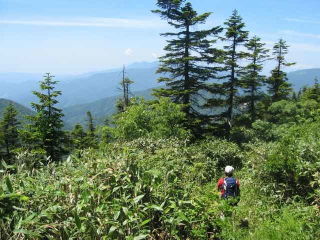
This is a two-day trip into the famous Oze marshland area. There are many differen routes available here, and you can also climb Hyuchigatake, but we didn't have time. On the first day, we climbed from Oshimizu over Sanpei-touge (pass) to Oze-numa, and stayed at the Chozo-goya mountain hut. This took about 3 hours. On the second day we walked over Sarafuse and Shirao mountains to Fujimi-touge (pass). From there it is a long walk down a gravel car road to the ski resort, where we had parked our car.
Dieses ist eine zweitägige Reise in den berühmten Oze Sumpflandbereich. Es gibt viele differen die Wege, die hier vorhanden sind, und Sie können Hyuchigatake auch klettern, aber wir didn't haben Zeit. Am ersten Tag kletterten wir von Oshimizu über Sanpei-touge (Pass) zu Oze-numa und blieben an der Chozo-goya Gebirgshütte. Dieses dauerte ungefähr 3 Stunden. Am zweiten Tag gingen wir über Sarafuse und Shirao Berge zu Fujimi-touge (Pass). Von gibt es ihm gehen hinunter eine Kiesautostraße zum Skierholungsort ein langes, in dem wir unser Auto geparkt hatten.
This is a two-day trip into the famous Oze marshland area. There are many differen routes available here, and you can also climb Hyuchigatake, but we didn't have time. On the first day, we climbed from Oshimizu over Sanpei-touge (pass) to Oze-numa, and stayed at the Chozo-goya mountain hut. This took about 3 hours. On the second day we walked over Sarafuse and Shirao mountains to Fujimi-touge (pass). From there it is a long walk down a gravel car road to the ski resort, where we had parked our car.
Ulteriori informazioni sotto
http://www.malcomson.com/gallery/oze2004Galleria itinerari
Mappa itinerario e altimetria
Altezza minima 1073 m
Altezza massima 2000 m
Maggiori informazioni sull'autore del tour

|
zangezur |
Commenti

English follows German.
Mit dem Auto können Sie zum Tokura Skierholungsort fahren, in dem Sie parken können (1000 Yen ein Tag), und verfangen dann sich ein Taxi zu Oshimizu. Es ist vermutlich einfacher, einen Zug von Tokyo zu Jomou-kougen vollständig zu erreichen, dann ein Bus zu Oshimizu. Dieser Weg ist von einem späten April bis das Ende November nur geöffnet. Im Winter sind alle Hütten geschlossen, und Oze ist eine zutreffende Winterwildnis mit bis 5 Metern Schnee. Nur für die mit kampierender Erfahrung des Winters.
By car, you can drive to Tokura ski resort, where you can park (1000 yen a day), and then catch a taxi to Oshimizu. It is probably easier to catch a train from Tokyo to Jomou-kougen, then a bus all the way to Oshimizu. This route is only open from late April until the end of November. In winter all the lodges are closed, and Oze is a true winter wilderness with up to 5 metres of snow. Only for those with winter camping experience.
Tracce GPS
Punti di traccia-
GPX / Garmin Map Source (gpx) download
-
TCX / Garmin Training Center® (tcx) download
-
CRS / Garmin Training Center® (crs) download
-
Google Earth (kml) download
-
G7ToWin (g7t) download
-
TTQV (trk) download
-
Overlay (ovl) download
-
Fugawi (txt) download
-
Kompass (DAV) Track (tk) download
-
Scheda tecnica (pdf) download
-
File originale dell'autore (g7t) download
Maggiori informazioni sull'autore del tour
|
|
zangezur |
Aggiungi ai miei preferiti
Rimuovi dai miei preferiti
Modifica dei tag
Tour aperto
Il mio voto
Vota