Login

Zabudli ste prihlasovacia meno

Cookies have to be accepted!
Your browser's cookie functionality is disabled. Please enable this functionality.

Not a member yet?

Register now
Login

Available for registred users only

Log in to use this feature.

Zabudli ste prihlasovacia meno

Cookies have to be accepted!
Your browser's cookie functionality is disabled. Please enable this functionality.

Not a member yet?

Register now
Filter
Kategórie
Advanced filters
  • Dĺžka (km)
  • výškomer
Uložiť filter Reset filter

TrackRank

QRCode

Technical data

Dĺžka11,7 km výškomer135 m Way down151 m Doba02:20 h:m dátum16.10.2010
ohodnotenia Author Kraj pôžitok z túry kondícia technika

štatistika

1475 náhľady ohodnotenia 17 Stiahnutia priemer
Rate
  • list trasy
  • príjazd
  • Stiahnutia

Canadiertour auf einem der schönsten Heideflüsse im Herbst im Rahmen unserer "Dreiflüssetour" neben der Alster und der Örtze.

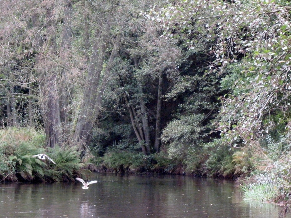
Bei der Tour auf der Böhme war es mit 8 °C schon recht kalt, wir waren aber entsprechend gekleidet und haben nachdem wir uns "warmgepaddelt" hatten nicht gefrohren. Die Natur an der Böhme ist faszinierend -  3 mal sahen wir Eisvögel. Umtragungsstellen gab es auf der Stecke keine.
Die Einsatzstelle liegt kurz hinter einem Wehr. Parkmöglichkeiten gibt es keine. Man muss also das Boot abladen und etwas ausserhalb der Stadtmitte parken.

Die Böhme ist von Februar bis zum 15. July jeden Jahres gesperrte und darf dann auch nur bei ausreichenden Pegelständen befahren werden. Mann sollte sich vorher über die Befahrungsregeln gut informieren! 

Further information at

http://de.wikipedia.org/wiki/B%C3%B6hme_(Fluss)

galéria trás

Mapa trasy a výškový profil

  • Open Street Map
  • Google
Minimum height -3 m Maximum height 45 m Detailný pohľad

More about the tour author

riemchens
Member since 2009

Send private message

komentáre

Von der A7 Abfahrt Bad Fallingbostel bis zur Böhmebrücke direkt in Bad Fallingbostel.

GPS trasy

Trackpoints
  • GPX / Garmin Map Source (gpx) download
  • TCX / Garmin Training Center® (tcx) download
  • CRS / Garmin Training Center® (crs) download
  • Google Earth (kml) download
  • G7ToWin (g7t) download
  • TTQV (trk) download
  • Overlay (ovl) download
  • Fugawi (txt) download
  • Kompass (DAV) Track (tk) download
  • list trasy (pdf) download
  • Original file of the author (gpx) download

More about the tour author

riemchens
Member since 2009

Send private message
Share track
Add to my favorites
Remove from my favorites
Edit tags
My score
Rate
trasa: Böhme - Dreiflüssetour
Druh: Lodné a kanoe
Dĺžka: 11,7 km
Evaluated on:
Doba:
Day(s)
Hour(s)
Minute(s)
ohodnotenie: Kraj pôžitok z túry kondícia technika