


Grenoble is surrounded by three mountain ranges: Chartreuse, Vercors and Belledonnes. During this trip we visited lower parts of Belledonnes.
We set off from the city as usual, but first we had to get to Vizille. We have chosen the mounatinous way through Commune de Brie-et-Angonnes.
As the overall trip is lenghty, so have another day to visit the remarkable castle and parc in the Vizille.
The real effort starts just as you leave Vizille. Ascend from 300 do 900 meters in 7 kilometers climb. If the wather is sunny, you will by dying at the top, but as a reward you can swim in the beautiful Grand Lac de Laffrey lake. The beach is at the northern end.
And it is just a beginning of the trip. Bike up and down along the lakes until you reach Pierre-Chatel. Then turn west to reach the valley of the Drac.
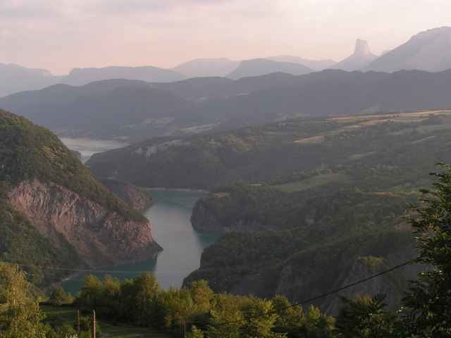
Finally enjoy almost 13 kilometers of not too steep descent watching breathtaking landscapes.
We set off from the city as usual, but first we had to get to Vizille. We have chosen the mounatinous way through Commune de Brie-et-Angonnes.
As the overall trip is lenghty, so have another day to visit the remarkable castle and parc in the Vizille.
The real effort starts just as you leave Vizille. Ascend from 300 do 900 meters in 7 kilometers climb. If the wather is sunny, you will by dying at the top, but as a reward you can swim in the beautiful Grand Lac de Laffrey lake. The beach is at the northern end.
And it is just a beginning of the trip. Bike up and down along the lakes until you reach Pierre-Chatel. Then turn west to reach the valley of the Drac.
Finally enjoy almost 13 kilometers of not too steep descent watching breathtaking landscapes.
Túra fotóalbuma
Túratérkép és magasságprofil
Minimum height 212 m
Maximum height 976 m
More about the tour author

|
azzie |
Megjegyzések
We started from Grenoble, but starting from Vizille should also be possible. In this case on the way back one should turn to Vizille in Champ-sur-Drac.
GPS trackek
Trackpoints-
GPX / Garmin Map Source (gpx) download
-
TCX / Garmin Training Center® (tcx) download
-
CRS / Garmin Training Center® (crs) download
-
Google Earth (kml) download
-
G7ToWin (g7t) download
-
TTQV (trk) download
-
Overlay (ovl) download
-
Fugawi (txt) download
-
Kompass (DAV) Track (tk) download
-
Túralap (pdf) download
-
Original file of the author (gpx) download
More about the tour author
|
|
azzie |
Add to my favorites
Remove from my favorites
Edit tags
Open track
My score
Rate
lol