Accesso

Hai dimenticato il login?

I cookie devono essere accettati!
La funzione cookie del suo browser è disattivata. Si prega di attivare la funzione.

Non sei ancora membro?

Registrati ora
Accesso

Possibile solo per gli utenti registrati

Effettua il login per poter utilizzare questa funzione.

Hai dimenticato il login?

I cookie devono essere accettati!
La funzione cookie del suo browser è disattivata. Si prega di attivare la funzione.

Non sei ancora membro?

Registrati ora
Filtro
Categorie
Filtri avanzati
  • Lunghezza (km)
  • Dislivello
Memorizza filtro Azzera il filtro

TrackRank

QRCode

Dati tecnici

Lunghezza27,9 km Dislivello1469 m Discesa1745 m Durata07:00 h:m Data01.11.2005
Valutazioni Autore User Paesaggio Divertimento Condizione Tecnica

Statistica

5198 Visualizzazioni 5 Valutazioni 582 Download 4.60 Media
Vota
  • Scheda tecnica
  • Come arrivare
  • Download

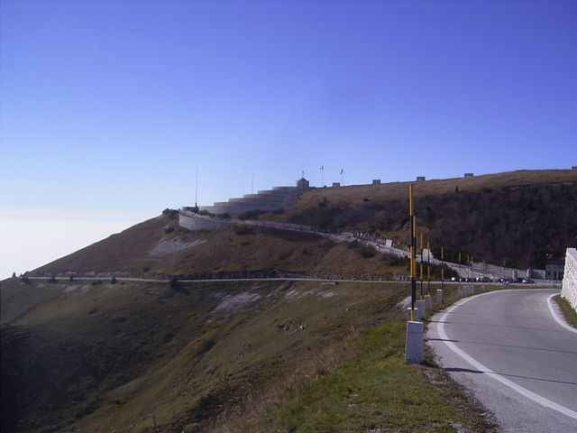
Tour on old donkey way from Bassano del Grappa - Crespano - Modonna del Cavallo to the Mt. Grappa monument (1st world war). 


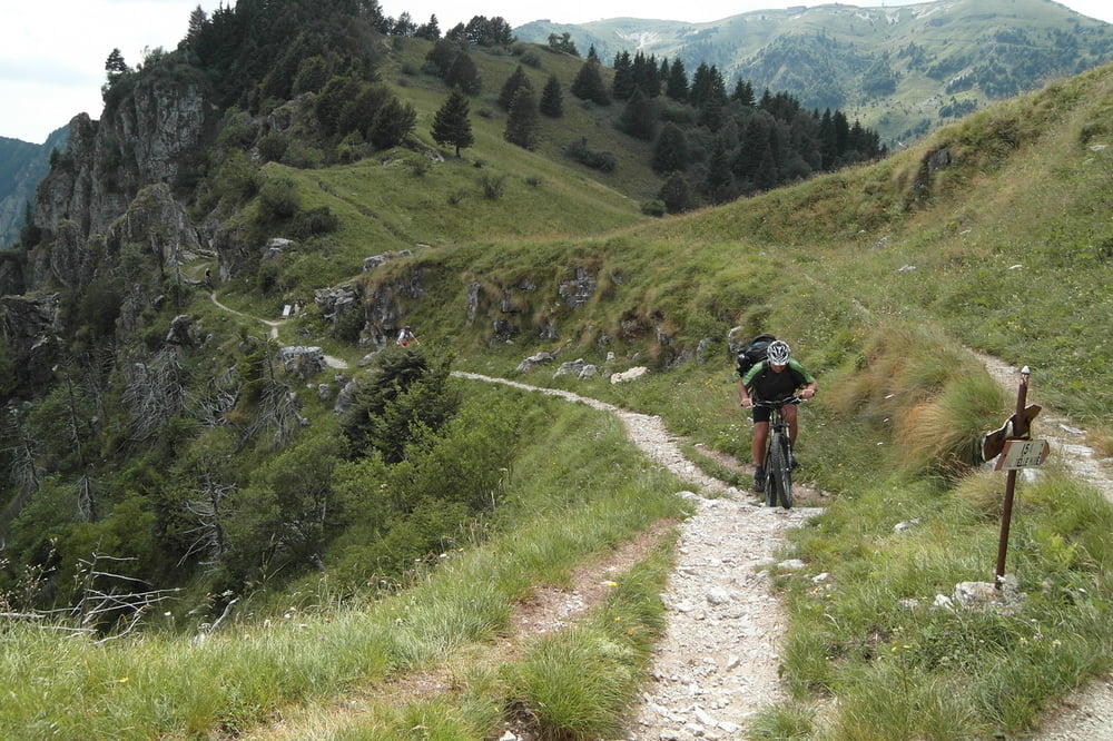
 The way down is going along a trail along the mountain top with some small walking passages, than on a spectacular trail cut into the mountain with spectacular view!. The way down to San Liberale is the sentiero 153 (S1-S2 level), a good biker can drive nearly everything, but be carefull in driving, the way is most of the time small and cut into the mountain.

  If you find the sentiero 153 to difficult, in about 3km is a easy way down to  San Liberale S0
 

August 2012 - track erneurert - Auffahrt nun komplett fahrbar

Galleria itinerari

Mappa itinerario e altimetria

  • Open Street Map
  • Google
Altezza minima 287 m Altezza massima 1734 m Vista dettagliata

Maggiori informazioni sull'autore del tour

skyhopper
Membro dal 2005

Invia un messaggio privato

Commenti

Checco on 21.12.2006

Error on the description

The sentiero of the way down in the track is not the CAI 151. I have do it, with my gps and the track of this tour does not corrisponding with my track (i have a photo of the real sentiero 151 too): http://81.208.98.134/FotoMountainBike/2006-12-17%20Grappa-cai%20151%20800x600/index.htm
I think that the sentiero in the track of this tour is the CAI 150. Next time that i going in the Monte Grappa, i'll do it.
Checco on 27.12.2006

Finally, I just do it. You have do the sentiero CAI 153 and i have found it VERY nice ! It's very spectacular. Thank you for this. I have same photo of it:
http://172.16.1.2/FotoMountainBike/2006-12-23%20Grappa%20Cai153%20800x600/index.htm
Trento on SS47 until exit Bssano, left to Romano Ezellino and Crespano. In Crespano on the traffic light left to Madonno di Cavallo church.

Tracce GPS

Punti di traccia
  • GPX / Garmin Map Source (gpx) download
  • TCX / Garmin Training Center® (tcx) download
  • CRS / Garmin Training Center® (crs) download
  • Google Earth (kml) download
  • G7ToWin (g7t) download
  • TTQV (trk) download
  • Overlay (ovl) download
  • Fugawi (txt) download
  • Kompass (DAV) Track (tk) download
  • Scheda tecnica (pdf) download
  • File originale dell'autore (gpx) download

Maggiori informazioni sull'autore del tour

skyhopper
Membro dal 2005

Invia un messaggio privato
Share track
Aggiungi ai miei preferiti
Rimuovi dai miei preferiti
Modifica dei tag
Il mio voto
Vota
Itinerario: Veneto: Bassano del Grappa - Crespano - Mt Grappa 1760m sentiero 153
Tipo: Mountain bike
Lunghezza: 27,9 km
Valutato su:
Durata:
Giorni/Diurni
Ora/Ore
Minuti
Valutazione: Paesaggio Divertimento Condizione Tecnica