Login

Zapomniałeś swój login?

Cookies have to be accepted!
Your browser's cookie functionality is disabled. Please enable this functionality.

Not a member yet?

Register now
Login

Available for registred users only

Log in to use this feature.

Zapomniałeś swój login?

Cookies have to be accepted!
Your browser's cookie functionality is disabled. Please enable this functionality.

Not a member yet?

Register now
Filter
Kategorie
Advanced filters
  • Długość (km)
  • Wysokość
Zapisz filtr Reset filter

TrackRank

QRCode

Technical data

Długość75,1 km Wysokość1332 m Way down1321 m Czas trwania00:00 h:m Data20.07.2012
Oceny Author Krajobraz Czynnik zadowolenia Kondycja Technika

Statystyka

187 Widoki Oceny 43 Downloads / Pliki do pobrania Przeciętnie
Rate
  • Karta trasy
  • Dojazd
  • Downloads / Pliki do pobrania
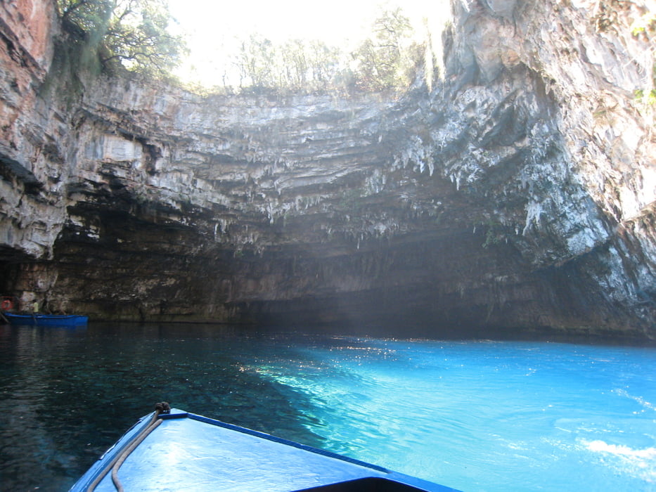
Schöne Route startet in Skala und geht entlang vom Meer nach Poros. Über Agios Nikolas durch ein schönes Tal hinunter an das schöne gelegene Sami. Dort befindet sich die sehenswerte unterirdische Höhle Melissani.

Galeria trasy

Mapa trasy i profil wysokości

  • Open Street Map
  • Google
Minimum height -9 m Maximum height 508 m Widok szczegółowy

More about the tour author

winiwin
Member since 2010

Send private message

Komentarze

GPS tracks

Trackpoints
  • GPX / Garmin Map Source (gpx) download
  • TCX / Garmin Training Center® (tcx) download
  • CRS / Garmin Training Center® (crs) download
  • Google Earth (kml) download
  • G7ToWin (g7t) download
  • TTQV (trk) download
  • Overlay (ovl) download
  • Fugawi (txt) download
  • Kompass (DAV) Track (tk) download
  • Karta trasy (pdf) download
  • Original file of the author (gpx) download

More about the tour author

winiwin
Member since 2010

Send private message
Share track
Add to my favorites
Remove from my favorites
Edit tags
My score
Rate
Trasa: Skala - Sami - Melissani
Rodzaj: Rower górski (MTB)
Długość: 75,1 km
Evaluated on:
Czas trwania:
Day(s)
Hour(s)
Minute(s)
Ocena: Krajobraz Czynnik zadowolenia Kondycja Technika