Login

Zapomniałeś swój login?

Cookies have to be accepted!
Your browser's cookie functionality is disabled. Please enable this functionality.

Not a member yet?

Register now
Login

Available for registred users only

Log in to use this feature.

Zapomniałeś swój login?

Cookies have to be accepted!
Your browser's cookie functionality is disabled. Please enable this functionality.

Not a member yet?

Register now
Filter
Kategorie
Advanced filters
  • Długość (km)
  • Wysokość
Zapisz filtr Reset filter

TrackRank

QRCode

Technical data

Długość14,7 km Wysokość1571 m Way down1561 m Czas trwania06:00 h:m Data17.03.2019
Oceny Author Krajobraz Czynnik zadowolenia Kondycja Technika

Statystyka

215 Widoki Oceny 22 Downloads / Pliki do pobrania Przeciętnie
Rate
  • Karta trasy
  • Dojazd
  • Downloads / Pliki do pobrania
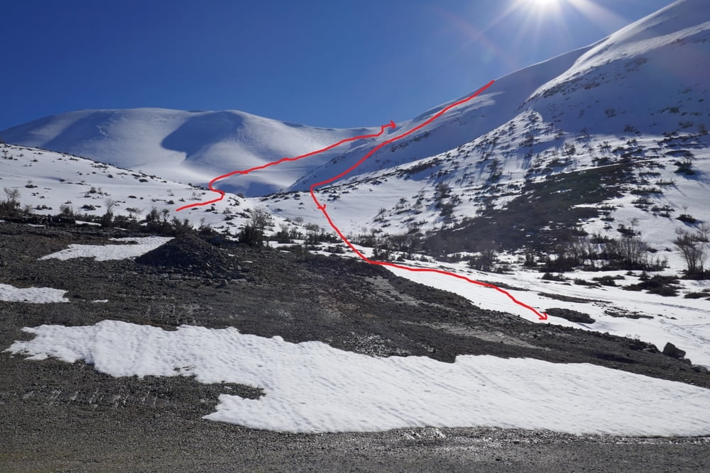
Vom Parkplatz ein Stück der eingeschneiten Straße folgen dann nicht dem großen Tal in Richtung Lakkos Mygerou Hütte folgen, sondern leicht inks das rampenartige Tal hinauf, zuletzt über die Flanke auf den Rücken, von hier unchwierig auf den Gipfel des Vouloumenou. Abfahrt nach Süden und durch das Tal hinab, soweit wie es Spaß macht. Dann den westlichen Rücken erklimmen und über diesen weiter bis zum Gipfel des Agathias. Abfahrt zuerst auf der Aufstiegsroute vom Vortag , dann aber weiter östlich eine tolle Flanke hinab ins Tal. Nun zuerst nach Osten und Wiederanstieg auf den Punkt  1855 nördlich des Tales. Von dort grandiose Abfahrt direkt zum Auto

Galeria trasy

Mapa trasy i profil wysokości

  • Open Street Map
  • Google
Minimum height 1272 m Maximum height 2360 m Widok szczegółowy

More about the tour author

Gi
Member since 2010

Send private message

Komentarze

Von Axos an Amigdalo (PP vom Vortag) vorbei und weiter in Richtung des ehemaligen Skiliftes. Parken an der Schneegrenze

GPS tracks

Trackpoints
  • GPX / Garmin Map Source (gpx) download
  • TCX / Garmin Training Center® (tcx) download
  • CRS / Garmin Training Center® (crs) download
  • Google Earth (kml) download
  • G7ToWin (g7t) download
  • TTQV (trk) download
  • Overlay (ovl) download
  • Fugawi (txt) download
  • Kompass (DAV) Track (tk) download
  • Karta trasy (pdf) download
  • Original file of the author (gpx) download

More about the tour author

Gi
Member since 2010

Send private message
Share track
Add to my favorites
Remove from my favorites
Edit tags
My score
Rate
Trasa: Agathias über Vouloumenou
Rodzaj: Narty
Długość: 14,7 km
Evaluated on:
Czas trwania:
Day(s)
Hour(s)
Minute(s)
Ocena: Krajobraz Czynnik zadowolenia Kondycja Technika