Login

Zapomniałeś swój login?

Cookies have to be accepted!
Your browser's cookie functionality is disabled. Please enable this functionality.

Not a member yet?

Register now
Login

Available for registred users only

Log in to use this feature.

Zapomniałeś swój login?

Cookies have to be accepted!
Your browser's cookie functionality is disabled. Please enable this functionality.

Not a member yet?

Register now
Filter
Kategorie
Advanced filters
  • Długość (km)
  • Wysokość
Zapisz filtr Reset filter

TrackRank

QRCode

Technical data

Długość15,8 km Wysokość326 m Way down324 m Czas trwania03:29 h:m Data23.08.2023
Oceny Author Krajobraz Czynnik zadowolenia Kondycja Technika

Statystyka

155 Widoki Oceny 0 Downloads / Pliki do pobrania Przeciętnie
Rate
  • Karta trasy
  • Dojazd
  • Downloads / Pliki do pobrania

Unsere Wanderung beginnt direkt beim Ferienhaus (Koordinaten siehe Anfahrtsbeschreibung).

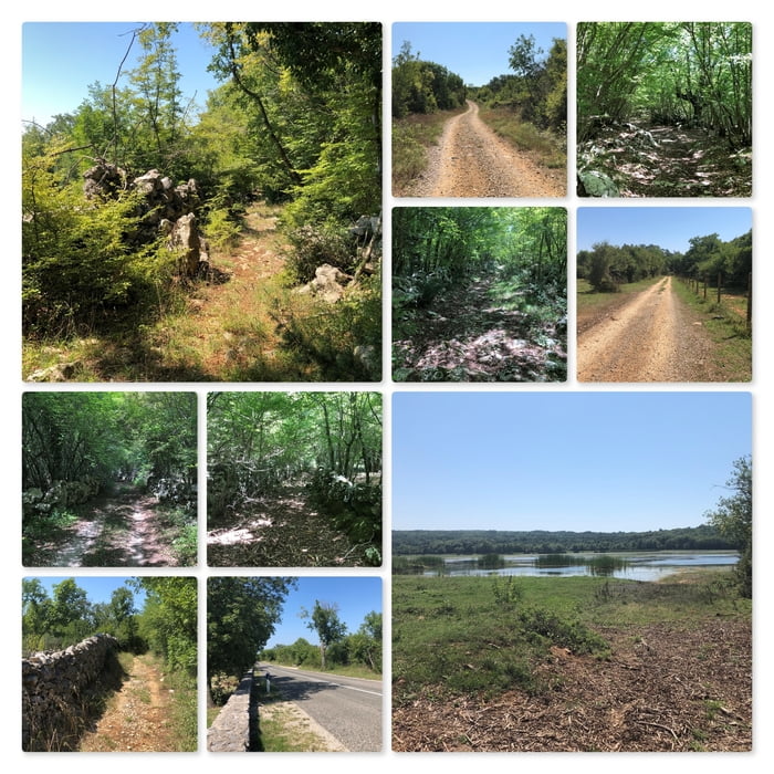
Das erste Stück führt über die Straße Kremenici (58070). Es geht an der Kirche Sv. Andrija vorbei. Bald biegen wir linkerhand in die Nebenstraße Ostrobradic ein. Unser Weg führt uns unter der Bundesstraße (102) durch und dann auf unbefestigten Wegen durch den Wald hinunter zum Ponikve See.

Ein Stück weit folgen wir dem See auf dem Weg am Ufer bis wir zu einer Hausruine kommen. Dort gehen wir auf der Schotterstraße weiter. Der weitere Weg geht dann wieder bergauf bis in die Ortschaft Gabonjin.

Nun müssen wir ca. 300 m auf der Straße (5087) gehen und biegen dann linkerhand auf einen geschotterten Weg ein. Wir folgen diesem Weg - über die Bundesstraße (102) - weiter bis wir wieder zurück an unserem Ausgangpunkt gelangt sind.

Further information at

http://villatonka.com/index.php?/family-house-rent/croatia/our-nook-of-paradise-by-the-sea

Mapa trasy i profil wysokości

  • Open Street Map
  • Google
Minimum height 21 m Maximum height 229 m Widok szczegółowy

More about the tour author

huberj59
Member since 2009

Send private message

Komentarze

Start der Wanderung an den Koordinaten: N45° 06' 54.7" E14° 32' 19.3" bzw. VILLA TONKA – Holiday house for rent in Croatia

GPS tracks

Trackpoints
  • GPX / Garmin Map Source (gpx) download
  • TCX / Garmin Training Center® (tcx) download
  • CRS / Garmin Training Center® (crs) download
  • Google Earth (kml) download
  • G7ToWin (g7t) download
  • TTQV (trk) download
  • Overlay (ovl) download
  • Fugawi (txt) download
  • Kompass (DAV) Track (tk) download
  • Karta trasy (pdf) download
  • Original file of the author (gpx) download

More about the tour author

huberj59
Member since 2009

Send private message
Share track
Add to my favorites
Remove from my favorites
Edit tags
My score
Rate
Trasa: HR - Barusici - Ponikve See - Giabonjin - Kremenici
Rodzaj: Wędrówki
Długość: 15,8 km
Evaluated on:
Czas trwania:
Day(s)
Hour(s)
Minute(s)
Ocena: Krajobraz Czynnik zadowolenia Kondycja Technika