Login

Zapomniałeś swój login?

Cookies have to be accepted!
Your browser's cookie functionality is disabled. Please enable this functionality.

Not a member yet?

Register now
Login

Available for registred users only

Log in to use this feature.

Zapomniałeś swój login?

Cookies have to be accepted!
Your browser's cookie functionality is disabled. Please enable this functionality.

Not a member yet?

Register now
Filter
Kategorie
Advanced filters
  • Długość (km)
  • Wysokość
Zapisz filtr Reset filter

TrackRank

QRCode

Technical data

Długość2,3 km Wysokość69 m Way down100 m Czas trwania00:40 h:m Data15.05.2011
Oceny Author Krajobraz Czynnik zadowolenia Kondycja Technika

Statystyka

809 Widoki Oceny 78 Downloads / Pliki do pobrania Przeciętnie
Rate
  • Karta trasy
  • Dojazd
  • Downloads / Pliki do pobrania

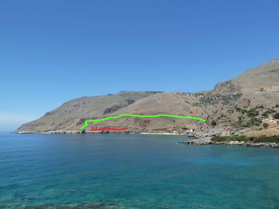
Many guidebooks describe the passage from Loutro to the Marmara-Bay (mouth of the Aradhena gorge) as being a bit "tricky", since this part of the E4 leads over some cliffs and a relatively small ledge some height above the sea.

The track you can download here provides an alternative path for people who want to avoid this passage. The detour costs about 20 minutes of extra time, but it will help hikers who do not want to try the difficult passage.

The track starts on the E4 shortly after Marmara Bay and rejoins the E4 at Finikas Bay (Finix).

Further information at

http://loutro.gr/

Galeria trasy

Mapa trasy i profil wysokości

  • Open Street Map
  • Google
Minimum height -3 m Maximum height 95 m Widok szczegółowy

More about the tour author

Kretakulk
Member since 2009

Send private message

Komentarze

The track branches off the E4 between Marmara and Loutro and rejoins the E4 at Finix.

GPS tracks

Trackpoints
  • GPX / Garmin Map Source (gpx) download
  • TCX / Garmin Training Center® (tcx) download
  • CRS / Garmin Training Center® (crs) download
  • Google Earth (kml) download
  • G7ToWin (g7t) download
  • TTQV (trk) download
  • Overlay (ovl) download
  • Fugawi (txt) download
  • Kompass (DAV) Track (tk) download
  • Karta trasy (pdf) download
  • Original file of the author (gpx) download

More about the tour author

Kretakulk
Member since 2009

Send private message
Share track
Add to my favorites
Remove from my favorites
Edit tags
My score
Rate
Trasa: Alternative path for difficult Marmara passage (E4)
Rodzaj: Wędrówki
Długość: 2,3 km
Evaluated on:
Czas trwania:
Day(s)
Hour(s)
Minute(s)
Ocena: Krajobraz Czynnik zadowolenia Kondycja Technika