Login

Si pozabil/a podatke za prijavo?

Cookies have to be accepted!
Your browser's cookie functionality is disabled. Please enable this functionality.

Not a member yet?

Register now
Login

Available for registred users only

Log in to use this feature.

Si pozabil/a podatke za prijavo?

Cookies have to be accepted!
Your browser's cookie functionality is disabled. Please enable this functionality.

Not a member yet?

Register now
Filter
Kategorije
Advanced filters
  • Dolžina (km)
  • Metri nadmorske višine
Shrani filter Reset filter

TrackRank

QRCode

Technical data

Dolžina8,6 km Metri nadmorske višine299 m Way down346 m Trajanje01:30 h:m Datum31.07.2008
Ocene Author Pokrajina Dejavnik zabave Kondicija Tehnika

Statistika

1603 Pogledi Ocene 106 Prenosi Povprečje
Rate
  • List z izleti
  • Prihod
  • Prenosi

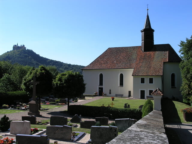
Auf dem Wanderparkplarz unterhalb der kleinen Kirche beginnt die wunderschöne Nordic Walking Runde.

SIe führt uns einmal rund um die Burg sowie an der Wallfahrtskirche Maria Zell vorbei.

Immer wieder haben wir einen fantastischen Blick auf die Burg, bei guter Fernsicht kann man auf der Bisingerseite bis in den Schwarzwald sehen.


TIP: Sollte nach der Tour der Hunger plagen, beim Parkplatz (Tourbeginn) ist eine schöne Grillstelle.

Im kleinen Dorf Boll lädt das Landgasthaus Kaiser mit seiner großen Speisekarte (Spezialität ist die riesige Maultaschenkarte) zum Verweilen ein.

Further information at

http://www.landgasthaus-kaiser.de/

Galerija izletov

Zemljevid in višinski profil izleta

  • Open Street Map
  • Google
Minimum height 635 m Maximum height 757 m Prikaz podrobnosti

More about the tour author

Furios-Wolf
Member since 2008

Send private message

Komentarji

Ausfahrt B27 Hechingen Süd, weiter Richtung Hechingen-Boll. In Boll der Ausschilderung Wallfahrtskirche Maria Zell folgen.

Poti GPS

Trackpoints
  • GPX / Garmin Map Source (gpx) download
  • TCX / Garmin Training Center® (tcx) download
  • CRS / Garmin Training Center® (crs) download
  • Google Earth (kml) download
  • G7ToWin (g7t) download
  • TTQV (trk) download
  • Overlay (ovl) download
  • Fugawi (txt) download
  • Kompass (DAV) Track (tk) download
  • List z izleti (pdf) download
  • Original file of the author (gpx) download

More about the tour author

Furios-Wolf
Member since 2008

Send private message
Share track
Add to my favorites
Remove from my favorites
Edit tags
My score
Rate
Izlet: Rund um den Hohenzollern
Vrsta: Nordijska hoja
Dolžina: 8,6 km
Evaluated on:
Trajanje:
Day(s)
Hour(s)
Minute(s)
Ocena: Pokrajina Dejavnik zabave Kondicija Tehnika