


Beindruckende Tour durch schwarze Lavafelder wo vor 100 Jahre noch der Chinyuero aktiv war.
Schwarze Piste und hellgrüne Kiefertannen die aus dieser Asche wachsen prägen das Gebiet.
Das Gestein durch das man fährt fühlt sich tatsächlich an wie Kohle.
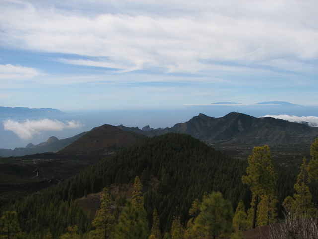
Man kann den jüngsten Vulkan Chinyuero auch umrunden, wir bevorzugten aber den Estrecho nebenan zu befahren, um von dort oben eine grandionse Aussicht über das Tenogebirge bis zu Gomera und Palma zu geniesen. Wie eine schraube dreht man sich diesem runden Berg hinauf, so dass man hinter jeder Kurve eine andere Fernsicht hat. Montana Negro, Chinyuero, Teide, Gomera, Palma, Teno, Montana Negro, Chinyuero...
Schwarze Piste und hellgrüne Kiefertannen die aus dieser Asche wachsen prägen das Gebiet.
Das Gestein durch das man fährt fühlt sich tatsächlich an wie Kohle.
Man kann den jüngsten Vulkan Chinyuero auch umrunden, wir bevorzugten aber den Estrecho nebenan zu befahren, um von dort oben eine grandionse Aussicht über das Tenogebirge bis zu Gomera und Palma zu geniesen. Wie eine schraube dreht man sich diesem runden Berg hinauf, so dass man hinter jeder Kurve eine andere Fernsicht hat. Montana Negro, Chinyuero, Teide, Gomera, Palma, Teno, Montana Negro, Chinyuero...
Further information at
http://danke-sagen.de/teneriffaGalerija izletov
Zemljevid in višinski profil izleta
Minimum height 1094 m
Maximum height 1543 m
More about the tour author
|
|
reviloilover |
Komentarji

Poti GPS
Trackpoints-
GPX / Garmin Map Source (gpx) download
-
TCX / Garmin Training Center® (tcx) download
-
CRS / Garmin Training Center® (crs) download
-
Google Earth (kml) download
-
G7ToWin (g7t) download
-
TTQV (trk) download
-
Overlay (ovl) download
-
Fugawi (txt) download
-
Kompass (DAV) Track (tk) download
-
List z izleti (pdf) download
-
Original file of the author (g7t) download
More about the tour author
|
|
reviloilover |
Add to my favorites
Remove from my favorites
Edit tags
Open track
My score
Rate